Bajo Corral geodata
Bajo Corral (Los Santos) is a seat of a third-order administrative division; located in Panama in America/Panama (GMT-5) time zone. With population of 192 people, there are 605 cities with bigger population in this country. Compared to other cities in Panama, 97.1% of cities are located further ↑North; 64.2% of cities are located further ←West and 72.5% of cities have lower elevation than Bajo Corral. Note1


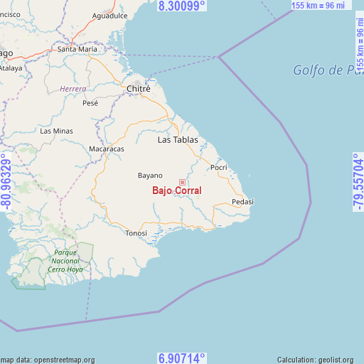
Bajo Corral GPS coordinates[2]
7° 36' 16.668" North, 80° 15' 36.576" West
| Map corner | latitude | longitude |
|---|---|---|
| Upper-left | 8.30099°, | -80.96329° |
| Center: | 7.60463°, | -80.26016° |
| Lower-right: | 6.90714°, | -79.55704° |
| Map W x H: | 155×155 km | = 96.3×96.3mi |
| max Lat: | 9.60898° ⇑97.1% North |
| Bajo Corral: | 7.60463° |
| min Lat: | ⇓2.9% South 7.26534° |
| min Long | Bajo Corral | max Long |
| -82.91275° | -80.26016° | -77.38965° |
| W 64.2%⇐ | ⇒35.8% E |
Elevation
Elevation of Bajo Corral is 176 m = 577 ft, and this is 3.9 m = 13 ft above average elevation for this country.
| Max E: |
2103 m = 6900 ft | 27.5% |
| Bajo Corral | 176 m 577 ft | |
| Avg. | 172.1 m = 565 ft | |
Min E: |
-1 m = -3 ft | 72.5% |
See also: Panama elevation on elevation.city.
Geographical zone
Bajo Corral is located in North Torrid zone (between Equator and Tropic of Cancer). Distance of Equator is 845.6 km =525.4 mi to South.| Distance of | km | miles | from Bajo Corral |
|---|---|---|---|
| North Pole | 9161.5 | 5692.7 | to North |
| Arctic Circle | 6555.6 | 4073.5 | to North |
| Tropic Cancer | 1760.4 | 1093.9 | to North |
| Equator | 845.6 | 525.4 | to South |


Nearby cities:
15 places around Bajo Corral: (largest is in red/bold)
• Bayano
13.7 km =8.5 mi,  281°
281°
• El Cañafístulo
3.3 km =2.1 mi,  63°
63°
• El Muñoz
10.4 km =6.5 mi,  319°
319°
• El Pedregoso
12.2 km =7.6 mi, 322°
• La Laja
14.1 km =8.8 mi,  3°
3°
• La Miel
8.9 km =5.5 mi,  236°
236°
• La Palma
11.7 km =7.3 mi,  36°
36°
• Nuario
11.1 km =6.9 mi,  221°
221°
• Oria Arriba
12.6 km =7.8 mi,  151°
151°
• Palmira
12.5 km =7.8 mi,  301°
301°
• Paritilla
10 km =6.2 mi,  74°
74°
• Peña Blanca
13 km =8.1 mi,  348°
348°
• San José
7.9 km =4.9 mi,  12°
12°
• Valle Rico
10.1 km =6.3 mi, 279°
• Vallerriquito
6.8 km =4.2 mi,  286°
286°
Sources, notices
• [Note1] Compared only with cities in Panama existing in our database
• [Src1] Map data: © OpenStreetMap contributors (CC-BY-SA)
• [Src2] Other city data from geonames.org with taken over terms of usage.
• [Src3] Geographical zone / Annual Mean Temperature by Robert A. Rohde @ Wikipedia
