Cañas geodata
Cañas (Los Santos) is a seat of a third-order administrative division; located in Panama in America/Panama (GMT-5) time zone. With population of 318 people, there are 552 cities with bigger population in this country. Compared to other cities in Panama, 98.9% of cities are located further ↑North; 63.9% of cities are located further ←West and 90.4% of cities have higher elevation than Cañas. Note1


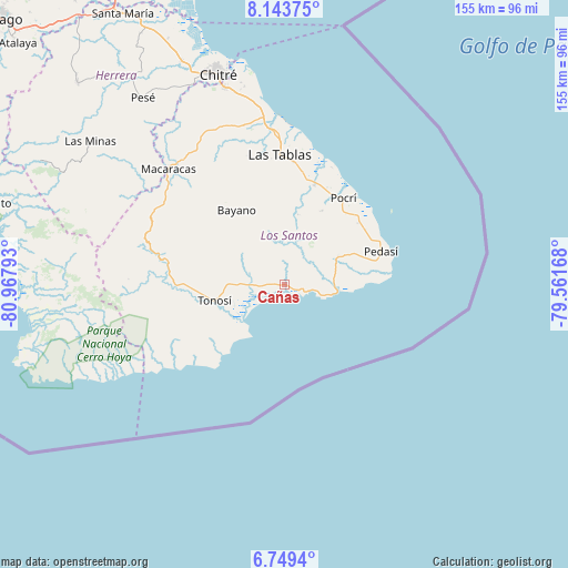
Cañas GPS coordinates[2]
7° 26' 49.668" North, 80° 15' 53.28" West
| Map corner | latitude | longitude |
|---|---|---|
| Upper-left | 8.14375°, | -80.96793° |
| Center: | 7.44713°, | -80.2648° |
| Lower-right: | 6.7494°, | -79.56168° |
| Map W x H: | 155×155 km | = 96.3×96.3mi |
| max Lat: | 9.60898° ⇑98.9% North |
| Cañas: | 7.44713° |
| min Lat: | ⇓1.1% South 7.26534° |
| min Long | Cañas | max Long |
| -82.91275° | -80.2648° | -77.38965° |
| W 63.9%⇐ | ⇒36.1% E |
Elevation
Elevation of Cañas is 12 m = 39 ft, and this is 160.1 m = 525 ft below average elevation for this country.
| Max E: |
2103 m = 6900 ft | 90.4% |
| Avg. | 172.1 m = 565 ft | |
| Cañas | 12 m = 39 ft | |
Min E: |
-1 m = -3 ft | 9.6% |
See also: Panama elevation on elevation.city.
Geographical zone
Cañas is located in North Torrid zone (between Equator and Tropic of Cancer). Distance of Equator is 828 km =514.5 mi to South.| Distance of | km | miles | from Cañas |
|---|---|---|---|
| North Pole | 9179 | 5703.6 | to North |
| Arctic Circle | 6573.1 | 4084.3 | to North |
| Tropic Cancer | 1777.9 | 1104.7 | to North |
| Equator | 828 | 514.5 | to South |


Nearby cities:
15 places around Cañas: (largest is in red/bold)
• Bajo Corral
17.5 km =10.9 mi,  1°
1°
• Bayano
24.1 km =15 mi,  327°
327°
• El Bebedero
21.5 km =13.4 mi,  258°
258°
• El Cacao
15.9 km =9.9 mi,  269°
269°
• El Cañafístulo
19.3 km =12 mi,  10°
10°
• Flores
16.1 km =10 mi,  283°
283°
• La Miel
14.3 km =8.9 mi, 331°
• Lajamina
21.3 km =13.2 mi,  43°
43°
• Los Asientos
16.2 km =10.1 mi,  61°
61°
• Nuario
11.5 km =7.1 mi,  323°
323°
• Oria Arriba
9.2 km =5.7 mi,  45°
45°
• Paritilla
22.6 km =14 mi,  26°
26°
• Tonosí
20.1 km =12.5 mi, 257°
• Valle Rico
21.4 km =13.3 mi, 333°
• Vallerriquito
20.3 km =12.6 mi,  342°
342°
Sources, notices
• [Note1] Compared only with cities in Panama existing in our database
• [Src1] Map data: © OpenStreetMap contributors (CC-BY-SA)
• [Src2] Other city data from geonames.org with taken over terms of usage.
• [Src3] Geographical zone / Annual Mean Temperature by Robert A. Rohde @ Wikipedia
