Chigoré geodata
Chigoré (Coclé) is a populated place; located in Panama in America/Panama (GMT-5) time zone. With population of 2,899 people, there are 95 cities with bigger population in this country. Compared to other cities in Panama, 56.9% of cities are located further ↓South; 60.1% of cities are located further ←West and 56.4% of cities have lower elevation than Chigoré. Note1


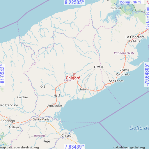
Chigoré GPS coordinates[2]
8° 31' 49.26" North, 80° 21' 4.212" West
| Map corner | latitude | longitude |
|---|---|---|
| Upper-left | 9.22505°, | -81.0543° |
| Center: | 8.53035°, | -80.35117° |
| Lower-right: | 7.83439°, | -79.64805° |
| Map W x H: | 154.6×154.6 km | = 96.1×96.1mi |
| max Lat: | 9.60898° ⇑43.1% North |
| Chigoré: | 8.53035° |
| min Lat: | ⇓56.9% South 7.26534° |
| min Long | Chigoré | max Long |
| -82.91275° | -80.35117° | -77.38965° |
| W 60.1%⇐ | ⇒39.9% E |
Elevation
Elevation of Chigoré is 92 m = 302 ft, and this is 80.1 m = 263 ft below average elevation for this country.
| Max E: |
2103 m = 6900 ft | 43.6% |
| Avg. | 172.1 m = 565 ft | |
| Chigoré | 92 m = 302 ft | |
Min E: |
-1 m = -3 ft | 56.4% |
See also: Panama elevation on elevation.city.
Geographical zone
Chigoré is located in North Torrid zone (between Equator and Tropic of Cancer). Distance of Equator is 948.5 km =589.4 mi to South.| Distance of | km | miles | from Chigoré |
|---|---|---|---|
| North Pole | 9058.6 | 5628.8 | to North |
| Arctic Circle | 6452.7 | 4009.5 | to North |
| Tropic Cancer | 1657.4 | 1029.9 | to North |
| Equator | 948.5 | 589.4 | to South |


Nearby cities:
15 places around Chigoré: (largest is in red/bold)
• Aguas Blancas
5.3 km =3.3 mi,  124°
124°
• Bella Vista
6.3 km =3.9 mi,  282°
282°
• Cañaveral
8.7 km =5.4 mi,  260°
260°
• Churuquita Chiquita
10.1 km =6.3 mi,  60°
60°
• Churuquita Grande
11.3 km =7 mi,  50°
50°
• Juan Díaz
10.7 km =6.6 mi,  135°
135°
• Las Delicias
2 km =1.2 mi,  308°
308°
• Las Lomas
3.5 km =2.2 mi,  225°
225°
• Llano Marín
6.6 km =4.1 mi,  154°
154°
• Los Uveros
4.8 km =3 mi,  267°
267°
• Pajonal Abajo
11.9 km =7.4 mi, 59°
• Penonomé
1.4 km =0.9 mi,  207°
207°
• Rincón de Las Palmas
11.5 km =7.1 mi,  75°
75°
• Sonadora
3.5 km =2.2 mi, 47°
• Vista Hermosa
2.6 km =1.6 mi, 261°
Sources, notices
• [Note1] Compared only with cities in Panama existing in our database
• [Src1] Map data: © OpenStreetMap contributors (CC-BY-SA)
• [Src2] Other city data from geonames.org with taken over terms of usage.
• [Src3] Geographical zone / Annual Mean Temperature by Robert A. Rohde @ Wikipedia
