Cañaveral geodata
Cañaveral (Coclé) is a seat of a third-order administrative division; located in Panama in America/Panama (GMT-5) time zone. With population of 827 people, there are 307 cities with bigger population in this country. Compared to other cities in Panama, 54.9% of cities are located further ↓South; 56% of cities are located further ←West and 67.4% of cities have higher elevation than Cañaveral. Note1


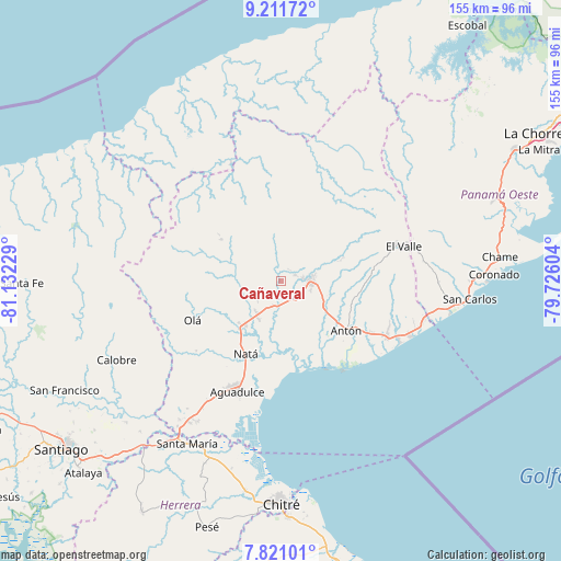
Cañaveral GPS coordinates[2]
8° 31' 1.2" North, 80° 25' 44.976" West
| Map corner | latitude | longitude |
|---|---|---|
| Upper-left | 9.21172°, | -81.13229° |
| Center: | 8.517°, | -80.42916° |
| Lower-right: | 7.82101°, | -79.72604° |
| Map W x H: | 154.6×154.6 km | = 96.1×96.1mi |
| max Lat: | 9.60898° ⇑45.1% North |
| Cañaveral: | 8.517° |
| min Lat: | ⇓54.9% South 7.26534° |
| min Long | Cañaveral | max Long |
| -82.91275° | -80.42916° | -77.38965° |
| W 56%⇐ | ⇒44% E |
Elevation
Elevation of Cañaveral is 39 m = 128 ft, and this is 133.1 m = 437 ft below average elevation for this country.
| Max E: |
2103 m = 6900 ft | 67.4% |
| Avg. | 172.1 m = 565 ft | |
| Cañaveral | 39 m = 128 ft | |
Min E: |
-1 m = -3 ft | 32.6% |
See also: Panama elevation on elevation.city.
Geographical zone
Cañaveral is located in North Torrid zone (between Equator and Tropic of Cancer). Distance of Equator is 947 km =588.4 mi to South.| Distance of | km | miles | from Cañaveral |
|---|---|---|---|
| North Pole | 9060.1 | 5629.7 | to North |
| Arctic Circle | 6454.2 | 4010.5 | to North |
| Tropic Cancer | 1658.9 | 1030.8 | to North |
| Equator | 947 | 588.4 | to South |


Nearby cities:
15 places around Cañaveral: (largest is in red/bold)
• Bella Vista
3.8 km =2.4 mi,  40°
40°
• Chigoré
8.7 km =5.4 mi,  80°
80°
• Ciruelito
7.5 km =4.7 mi,  197°
197°
• Coclé
6.8 km =4.2 mi,  179°
179°
• El Congo
8.9 km =5.5 mi, 175°
• El Potrero
9.7 km =6 mi,  272°
272°
• La Candelaria
10.9 km =6.8 mi,  217°
217°
• La Pintada
8.6 km =5.3 mi,  349°
349°
• Las Delicias
7.5 km =4.7 mi,  68°
68°
• Las Lomas
6.2 km =3.9 mi,  99°
99°
• Los Uveros
4 km =2.5 mi, 70°
• Penonomé
7.9 km =4.9 mi,  88°
88°
• Río Grande
11.7 km =7.3 mi,  211°
211°
• Sonadora
11.8 km =7.3 mi, 70°
• Vista Hermosa
6.1 km =3.8 mi, 79°
Sources, notices
• [Note1] Compared only with cities in Panama existing in our database
• [Src1] Map data: © OpenStreetMap contributors (CC-BY-SA)
• [Src2] Other city data from geonames.org with taken over terms of usage.
• [Src3] Geographical zone / Annual Mean Temperature by Robert A. Rohde @ Wikipedia
