Bijagual geodata
Bijagual (Coclé) is a populated place; located in Panama in America/Panama (GMT-5) time zone. With population of 865 people, there are 297 cities with bigger population in this country. Compared to other cities in Panama, 60.6% of cities are located further ↑North; 64.5% of cities are located further ←West and 79.6% of cities have higher elevation than Bijagual. Note1


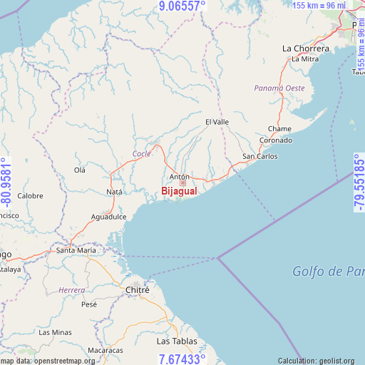
Bijagual GPS coordinates[2]
8° 22' 14.052" North, 80° 15' 17.892" West
| Map corner | latitude | longitude |
|---|---|---|
| Upper-left | 9.06557°, | -80.9581° |
| Center: | 8.37057°, | -80.25497° |
| Lower-right: | 7.67433°, | -79.55185° |
| Map W x H: | 154.7×154.7 km | = 96.1×96.1mi |
| max Lat: | 9.60898° ⇑60.6% North |
| Bijagual: | 8.37057° |
| min Lat: | ⇓39.4% South 7.26534° |
| min Long | Bijagual | max Long |
| -82.91275° | -80.25497° | -77.38965° |
| W 64.5%⇐ | ⇒35.5% E |
Elevation
Elevation of Bijagual is 24 m = 79 ft, and this is 148.1 m = 486 ft below average elevation for this country.
| Max E: |
2103 m = 6900 ft | 79.6% |
| Avg. | 172.1 m = 565 ft | |
| Bijagual | 24 m = 79 ft | |
Min E: |
-1 m = -3 ft | 20.4% |
See also: Panama elevation on elevation.city.
Geographical zone
Bijagual is located in North Torrid zone (between Equator and Tropic of Cancer). Distance of Equator is 930.7 km =578.3 mi to South.| Distance of | km | miles | from Bijagual |
|---|---|---|---|
| North Pole | 9076.3 | 5639.7 | to North |
| Arctic Circle | 6470.5 | 4020.6 | to North |
| Tropic Cancer | 1675.2 | 1040.9 | to North |
| Equator | 930.7 | 578.3 | to South |


Nearby cities:
15 places around Bijagual: (largest is in red/bold)
• Antón
3 km =1.9 mi,  348°
348°
• Buen Retiro
5.7 km =3.5 mi,  23°
23°
• El Chirú
8.1 km =5 mi,  67°
67°
• El Coco
10.9 km =6.8 mi,  285°
285°
• Farallón
13 km =8.1 mi,  96°
96°
• Guabas Arriba
10.3 km =6.4 mi,  356°
356°
• Juan Díaz
10.7 km =6.6 mi,  343°
343°
• Llano Grande
9.4 km =5.8 mi, 19°
• Llano Marín
14.1 km =8.8 mi,  326°
326°
• Los Pollos
11.2 km =7 mi, 73°
• Palo Verde
6.6 km =4.1 mi, 73°
• Pueblo Nuevo
6.1 km =3.8 mi, 72°
• Río Hato
9.8 km =6.1 mi,  84°
84°
• Santa Clara
16 km =9.9 mi,  85°
85°
• Santa Rita
15.8 km =9.8 mi,  30°
30°
Sources, notices
• [Note1] Compared only with cities in Panama existing in our database
• [Src1] Map data: © OpenStreetMap contributors (CC-BY-SA)
• [Src2] Other city data from geonames.org with taken over terms of usage.
• [Src3] Geographical zone / Annual Mean Temperature by Robert A. Rohde @ Wikipedia
