Llano Grande geodata
Llano Grande (Coclé) is a seat of a third-order administrative division; located in Panama in America/Panama (GMT-5) time zone. In our database, there are 694 cities with bigger population. Compared to other cities in Panama, 53.1% of cities are located further ↑North; 66.1% of cities are located further ←West and 52.6% of cities have lower elevation than Llano Grande. Note1


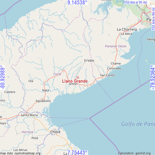
Llano Grande GPS coordinates[2]
8° 27' 1.908" North, 80° 13' 36.336" West
| Map corner | latitude | longitude |
|---|---|---|
| Upper-left | 9.14538°, | -80.92989° |
| Center: | 8.45053°, | -80.22676° |
| Lower-right: | 7.75443°, | -79.52364° |
| Map W x H: | 154.7×154.7 km | = 96.1×96.1mi |
| max Lat: | 9.60898° ⇑53.1% North |
| Llano Grande: | 8.45053° |
| min Lat: | ⇓46.9% South 7.26534° |
| min Long | Llano Grande | max Long |
| -82.91275° | -80.22676° | -77.38965° |
| W 66.1%⇐ | ⇒33.9% E |
Elevation
Elevation of Llano Grande is 79 m = 259 ft, and this is 93.1 m = 305 ft below average elevation for this country.
| Max E: |
2103 m = 6900 ft | 47.4% |
| Avg. | 172.1 m = 565 ft | |
| Llano Grande | 79 m = 259 ft | |
Min E: |
-1 m = -3 ft | 52.6% |
See also: Panama elevation on elevation.city.
Geographical zone
Llano Grande is located in North Torrid zone (between Equator and Tropic of Cancer). Distance of Equator is 939.6 km =583.8 mi to South.| Distance of | km | miles | from Llano Grande |
|---|---|---|---|
| North Pole | 9067.5 | 5634.3 | to North |
| Arctic Circle | 6461.6 | 4015.1 | to North |
| Tropic Cancer | 1666.3 | 1035.4 | to North |
| Equator | 939.6 | 583.8 | to South |


Nearby cities:
15 places around Llano Grande: (largest is in red/bold)
• Aguas Blancas
11 km =6.8 mi,  302°
302°
• Antón
7 km =4.3 mi,  212°
212°
• Bijagual
9.4 km =5.8 mi,  199°
199°
• Buen Retiro
3.7 km =2.3 mi,  193°
193°
• Caballero
10.8 km =6.7 mi,  17°
17°
• El Chirú
7.2 km =4.5 mi,  142°
142°
• El Retiro
8.6 km =5.3 mi,  67°
67°
• Guabas Arriba
4 km =2.5 mi,  291°
291°
• Juan Díaz
6.3 km =3.9 mi,  282°
282°
• Los Pollos
9.6 km =6 mi,  126°
126°
• Palo Verde
7.7 km =4.8 mi,  155°
155°
• Pueblo Nuevo
7.6 km =4.7 mi, 159°
• Río Hato
10.3 km =6.4 mi, 139°
• San Juan de Dios
11.2 km =7 mi,  0°
0°
• Santa Rita
6.7 km =4.2 mi,  45°
45°
Sources, notices
• [Note1] Compared only with cities in Panama existing in our database
• [Src1] Map data: © OpenStreetMap contributors (CC-BY-SA)
• [Src2] Other city data from geonames.org with taken over terms of usage.
• [Src3] Geographical zone / Annual Mean Temperature by Robert A. Rohde @ Wikipedia
