Santa Clara geodata
Santa Clara (Coclé) is a populated place; located in Panama in America/Panama (GMT-5) time zone. With population of 597 people, there are 414 cities with bigger population in this country. Compared to other cities in Panama, 59.4% of cities are located further ↑North; 70.3% of cities are located further ←West and 71.7% of cities have higher elevation than Santa Clara. Note1


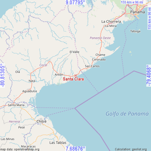
Santa Clara GPS coordinates[2]
8° 22' 58.728" North, 80° 6' 35.712" West
| Map corner | latitude | longitude |
|---|---|---|
| Upper-left | 9.07795°, | -80.81305° |
| Center: | 8.38298°, | -80.10992° |
| Lower-right: | 7.68676°, | -79.4068° |
| Map W x H: | 154.7×154.7 km | = 96.1×96.1mi |
| max Lat: | 9.60898° ⇑59.4% North |
| Santa Clara: | 8.38298° |
| min Lat: | ⇓40.6% South 7.26534° |
| min Long | Santa Clara | max Long |
| -82.91275° | -80.10992° | -77.38965° |
| W 70.3%⇐ | ⇒29.7% E |
Elevation
Elevation of Santa Clara is 34 m = 112 ft, and this is 138.1 m = 453 ft below average elevation for this country.
| Max E: |
2103 m = 6900 ft | 71.7% |
| Avg. | 172.1 m = 565 ft | |
| Santa Clara | 34 m = 112 ft | |
Min E: |
-1 m = -3 ft | 28.3% |
See also: Panama elevation on elevation.city.
Geographical zone
Santa Clara is located in North Torrid zone (between Equator and Tropic of Cancer). Distance of Equator is 932.1 km =579.2 mi to South.| Distance of | km | miles | from Santa Clara |
|---|---|---|---|
| North Pole | 9075 | 5638.9 | to North |
| Arctic Circle | 6469.1 | 4019.7 | to North |
| Tropic Cancer | 1673.8 | 1040.1 | to North |
| Equator | 932.1 | 579.2 | to South |


Nearby cities:
15 places around Santa Clara: (largest is in red/bold)
• Buen Retiro
14.3 km =8.9 mi,  285°
285°
• El Chirú
8.7 km =5.4 mi,  281°
281°
• El Espino
15 km =9.3 mi,  45°
45°
• El Higo
10.8 km =6.7 mi, 48°
• El Retiro
11.9 km =7.4 mi,  335°
335°
• Farallón
4.2 km =2.6 mi,  225°
225°
• La Ermita
9.3 km =5.8 mi,  29°
29°
• Las Matas
9.8 km =6.1 mi,  11°
11°
• Las Uvas
14.7 km =9.1 mi, 54°
• Llano Grande
14.9 km =9.3 mi,  300°
300°
• Los Pollos
5.5 km =3.4 mi, 288°
• Palo Verde
9.6 km =6 mi,  273°
273°
• Pueblo Nuevo
10.2 km =6.3 mi, 272°
• Río Hato
6.2 km =3.9 mi, 266°
• Santa Rita
14.6 km =9.1 mi,  326°
326°
Sources, notices
• [Note1] Compared only with cities in Panama existing in our database
• [Src1] Map data: © OpenStreetMap contributors (CC-BY-SA)
• [Src2] Other city data from geonames.org with taken over terms of usage.
• [Src3] Geographical zone / Annual Mean Temperature by Robert A. Rohde @ Wikipedia
