El Chirú geodata
El Chirú (Coclé) is a seat of a third-order administrative division; located in Panama in America/Panama (GMT-5) time zone. With population of 531 people, there are 460 cities with bigger population in this country. Compared to other cities in Panama, 57.6% of cities are located further ↑North; 68.3% of cities are located further ←West and 61.3% of cities have higher elevation than El Chirú. Note1


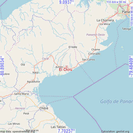
El Chirú GPS coordinates[2]
8° 23' 55.536" North, 80° 11' 13.956" West
| Map corner | latitude | longitude |
|---|---|---|
| Upper-left | 9.0937°, | -80.89034° |
| Center: | 8.39876°, | -80.18721° |
| Lower-right: | 7.70257°, | -79.48409° |
| Map W x H: | 154.7×154.7 km | = 96.1×96.1mi |
| max Lat: | 9.60898° ⇑57.6% North |
| El Chirú: | 8.39876° |
| min Lat: | ⇓42.4% South 7.26534° |
| min Long | El Chirú | max Long |
| -82.91275° | -80.18721° | -77.38965° |
| W 68.3%⇐ | ⇒31.7% E |
Elevation
Elevation of El Chirú is 50 m = 164 ft, and this is 122.1 m = 401 ft below average elevation for this country.
| Max E: |
2103 m = 6900 ft | 61.3% |
| Avg. | 172.1 m = 565 ft | |
| El Chirú | 50 m = 164 ft | |
Min E: |
-1 m = -3 ft | 38.7% |
See also: Panama elevation on elevation.city.
Geographical zone
El Chirú is located in North Torrid zone (between Equator and Tropic of Cancer). Distance of Equator is 933.9 km =580.3 mi to South.| Distance of | km | miles | from El Chirú |
|---|---|---|---|
| North Pole | 9073.2 | 5637.8 | to North |
| Arctic Circle | 6467.3 | 4018.6 | to North |
| Tropic Cancer | 1672.1 | 1039 | to North |
| Equator | 933.9 | 580.3 | to South |


Nearby cities:
15 places around El Chirú: (largest is in red/bold)
• Antón
8.1 km =5 mi,  268°
268°
• Bijagual
8.1 km =5 mi,  247°
247°
• Buen Retiro
5.6 km =3.5 mi,  292°
292°
• El Retiro
9.7 km =6 mi,  21°
21°
• Farallón
7.2 km =4.5 mi,  130°
130°
• Guabas Arriba
10.8 km =6.7 mi,  311°
311°
• Juan Díaz
12.7 km =7.9 mi,  303°
303°
• Las Matas
13.1 km =8.1 mi,  53°
53°
• Llano Grande
7.2 km =4.5 mi,  322°
322°
• Los Pollos
3.3 km =2.1 mi,  89°
89°
• Palo Verde
1.6 km =1 mi,  222°
222°
• Pueblo Nuevo
2.1 km =1.3 mi,  231°
231°
• Río Hato
3.2 km =2 mi, 132°
• Santa Clara
8.7 km =5.4 mi,  101°
101°
• Santa Rita
10.5 km =6.5 mi,  2°
2°
Sources, notices
• [Note1] Compared only with cities in Panama existing in our database
• [Src1] Map data: © OpenStreetMap contributors (CC-BY-SA)
• [Src2] Other city data from geonames.org with taken over terms of usage.
• [Src3] Geographical zone / Annual Mean Temperature by Robert A. Rohde @ Wikipedia
