Alto Caballero geodata
Alto Caballero (Ngöbe-Buglé) is a seat of a third-order administrative division; located in Panama in America/Panama (GMT-5) time zone. In our database, there are 694 cities with bigger population. Compared to other cities in Panama, 67.4% of cities are located further ↑North; 72.5% of cities are located further →East and 90.4% of cities have lower elevation than Alto Caballero. Note1


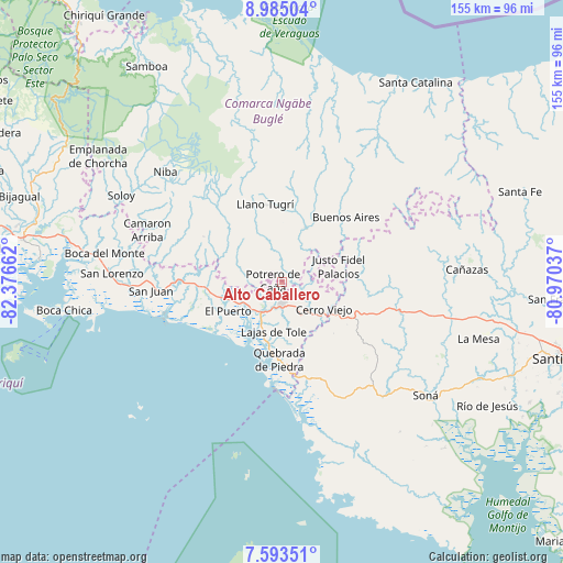
Alto Caballero GPS coordinates[2]
8° 17' 23.604" North, 81° 40' 24.564" West
| Map corner | latitude | longitude |
|---|---|---|
| Upper-left | 8.98504°, | -82.37662° |
| Center: | 8.28989°, | -81.67349° |
| Lower-right: | 7.59351°, | -80.97037° |
| Map W x H: | 154.7×154.7 km | = 96.1×96.1mi |
| max Lat: | 9.60898° ⇑67.4% North |
| Alto Caballero: | 8.28989° |
| min Lat: | ⇓32.6% South 7.26534° |
| min Long | Alto Caballero | max Long |
| -82.91275° | -81.67349° | -77.38965° |
| W 27.5%⇐ | ⇒72.5% E |
Elevation
Elevation of Alto Caballero is 446 m = 1463 ft, and this is 273.9 m = 899 ft above average elevation for this country.
| Max E: |
2103 m = 6900 ft | 9.6% |
| Alto Caballero | 446 m 1463 ft | |
| Avg. | 172.1 m = 565 ft | |
Min E: |
-1 m = -3 ft | 90.4% |
See also: Panama elevation on elevation.city.
Geographical zone
Alto Caballero is located in North Torrid zone (between Equator and Tropic of Cancer). Distance of Equator is 921.7 km =572.7 mi to South.| Distance of | km | miles | from Alto Caballero |
|---|---|---|---|
| North Pole | 9085.3 | 5645.3 | to North |
| Arctic Circle | 6479.4 | 4026.1 | to North |
| Tropic Cancer | 1684.2 | 1046.5 | to North |
| Equator | 921.7 | 572.7 | to South |


Nearby cities:
15 places around Alto Caballero: (largest is in red/bold)
• Bella Vista
10.9 km =6.8 mi,  148°
148°
• Cabecera de Cerro Puerco
10 km =6.2 mi,  288°
288°
• Cerro Caña
9.8 km =6.1 mi,  45°
45°
• Cerro Mosquito
6.7 km =4.2 mi,  344°
344°
• Chichica
7.7 km =4.8 mi,  6°
6°
• Chichica
8.6 km =5.3 mi, 5°
• El Nancito
8.7 km =5.4 mi,  228°
228°
• Lajero Arriba
10.7 km =6.6 mi,  270°
270°
• Llano Limón
5.4 km =3.4 mi,  159°
159°
• Maraca
11 km =6.8 mi,  327°
327°
• Peña Prieta
10.2 km =6.3 mi, 331°
• Potrero de Caña
2.8 km =1.7 mi,  278°
278°
• Pueblo Viejo
4.5 km =2.8 mi, 164°
• Tolé
5.6 km =3.5 mi,  177°
177°
• Veladero
6.8 km =4.2 mi, 161°
Sources, notices
• [Note1] Compared only with cities in Panama existing in our database
• [Src1] Map data: © OpenStreetMap contributors (CC-BY-SA)
• [Src2] Other city data from geonames.org with taken over terms of usage.
• [Src3] Geographical zone / Annual Mean Temperature by Robert A. Rohde @ Wikipedia
