Pueblo Viejo geodata
Pueblo Viejo (Chiriquí) is a populated place; located in Panama in America/Panama (GMT-5) time zone. With population of 1,042 people, there are 246 cities with bigger population in this country. Compared to other cities in Panama, 69.1% of cities are located further ↑North; 72% of cities are located further →East and 85.1% of cities have lower elevation than Pueblo Viejo. Note1


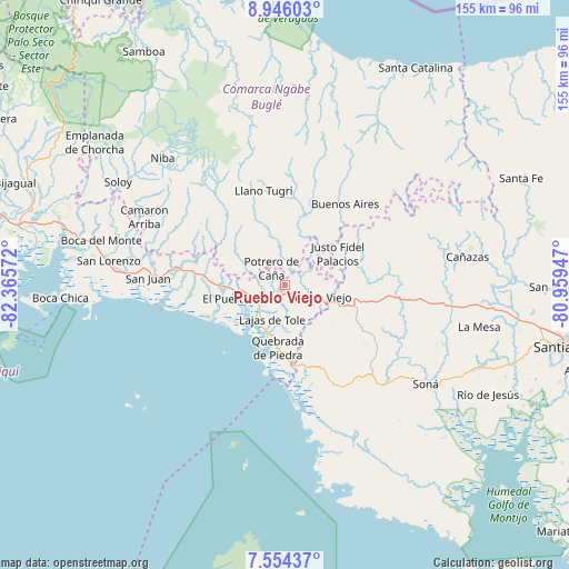
Pueblo Viejo GPS coordinates[2]
8° 15' 2.916" North, 81° 39' 45.324" West
| Map corner | latitude | longitude |
|---|---|---|
| Upper-left | 8.94603°, | -82.36572° |
| Center: | 8.25081°, | -81.66259° |
| Lower-right: | 7.55437°, | -80.95947° |
| Map W x H: | 154.7×154.7 km | = 96.1×96.1mi |
| max Lat: | 9.60898° ⇑69.1% North |
| Pueblo Viejo: | 8.25081° |
| min Lat: | ⇓30.9% South 7.26534° |
| min Long | Pueblo Viejo | max Long |
| -82.91275° | -81.66259° | -77.38965° |
| W 28%⇐ | ⇒72% E |
Elevation
Elevation of Pueblo Viejo is 339 m = 1112 ft, and this is 166.9 m = 548 ft above average elevation for this country.
| Max E: |
2103 m = 6900 ft | 14.9% |
| Pueblo Viejo | 339 m 1112 ft | |
| Avg. | 172.1 m = 565 ft | |
Min E: |
-1 m = -3 ft | 85.1% |
See also: Panama elevation on elevation.city.
Geographical zone
Pueblo Viejo is located in North Torrid zone (between Equator and Tropic of Cancer). Distance of Equator is 917.4 km =570 mi to South.| Distance of | km | miles | from Pueblo Viejo |
|---|---|---|---|
| North Pole | 9089.7 | 5648.1 | to North |
| Arctic Circle | 6483.8 | 4028.8 | to North |
| Tropic Cancer | 1688.5 | 1049.2 | to North |
| Equator | 917.4 | 570 | to South |


Nearby cities:
15 places around Pueblo Viejo: (largest is in red/bold)
• Alto Caballero
4.5 km =2.8 mi,  344°
344°
• Bella Vista
6.7 km =4.2 mi,  137°
137°
• Cerro Caña
12.6 km =7.8 mi,  27°
27°
• Cerro Mosquito
11.2 km =7 mi, 344°
• Cerro Venado
10 km =6.2 mi,  104°
104°
• Cerro Viejo
9.5 km =5.9 mi,  88°
88°
• Chichica
12 km =7.5 mi,  358°
358°
• Chichica
12.9 km =8 mi, 358°
• El Nancito
7.8 km =4.8 mi,  259°
259°
• Lajas de Tolé
9.7 km =6 mi,  202°
202°
• Lajero Arriba
12.7 km =7.9 mi,  290°
290°
• Llano Limón
1 km =0.6 mi, 135°
• Potrero de Caña
6.2 km =3.9 mi,  319°
319°
• Tolé
1.6 km =1 mi,  219°
219°
• Veladero
2.4 km =1.5 mi,  156°
156°
Sources, notices
• [Note1] Compared only with cities in Panama existing in our database
• [Src1] Map data: © OpenStreetMap contributors (CC-BY-SA)
• [Src2] Other city data from geonames.org with taken over terms of usage.
• [Src3] Geographical zone / Annual Mean Temperature by Robert A. Rohde @ Wikipedia
