Cerro Caña geodata
Cerro Caña (Ngöbe-Buglé) is a seat of a third-order administrative division; located in Panama in America/Panama (GMT-5) time zone. With population of 319 people, there are 550 cities with bigger population in this country. Compared to other cities in Panama, 62.3% of cities are located further ↑North; 71.4% of cities are located further →East and 89% of cities have lower elevation than Cerro Caña. Note1


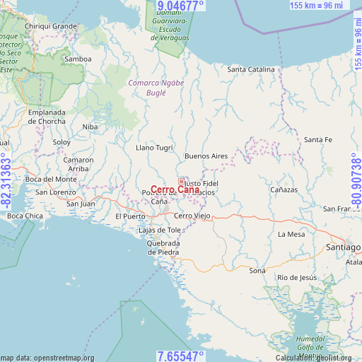
Cerro Caña GPS coordinates[2]
8° 21' 6.264" North, 81° 36' 37.8" West
| Map corner | latitude | longitude |
|---|---|---|
| Upper-left | 9.04677°, | -82.31363° |
| Center: | 8.35174°, | -81.6105° |
| Lower-right: | 7.65547°, | -80.90738° |
| Map W x H: | 154.7×154.7 km | = 96.1×96.1mi |
| max Lat: | 9.60898° ⇑62.3% North |
| Cerro Caña: | 8.35174° |
| min Lat: | ⇓37.7% South 7.26534° |
| min Long | Cerro Caña | max Long |
| -82.91275° | -81.6105° | -77.38965° |
| W 28.6%⇐ | ⇒71.4% E |
Elevation
Elevation of Cerro Caña is 429 m = 1407 ft, and this is 256.9 m = 843 ft above average elevation for this country.
| Max E: |
2103 m = 6900 ft | 11% |
| Cerro Caña | 429 m 1407 ft | |
| Avg. | 172.1 m = 565 ft | |
Min E: |
-1 m = -3 ft | 89% |
See also: Panama elevation on elevation.city.
Geographical zone
Cerro Caña is located in North Torrid zone (between Equator and Tropic of Cancer). Distance of Equator is 928.6 km =577 mi to South.| Distance of | km | miles | from Cerro Caña |
|---|---|---|---|
| North Pole | 9078.4 | 5641.1 | to North |
| Arctic Circle | 6472.5 | 4021.8 | to North |
| Tropic Cancer | 1677.3 | 1042.2 | to North |
| Equator | 928.6 | 577 | to South |


Nearby cities:
15 places around Cerro Caña: (largest is in red/bold)
• Alto Caballero
9.8 km =6.1 mi,  225°
225°
• Bajo Solis
9 km =5.6 mi,  93°
93°
• Cerro Iglesias
6.3 km =3.9 mi,  125°
125°
• Cerro Mosquito
8.7 km =5.4 mi,  267°
267°
• Cerro Viejo
11.5 km =7.1 mi,  161°
161°
• Chichica
6.1 km =3.8 mi,  277°
277°
• Chichica
6.4 km =4 mi,  285°
285°
• Llano Limón
12.9 km =8 mi,  202°
202°
• Llano Ñopo
7.6 km =4.7 mi,  353°
353°
• Peña Prieta
11.9 km =7.4 mi, 280°
• Potrero de Caña
11.7 km =7.3 mi,  236°
236°
• Pueblo Viejo
12.6 km =7.8 mi,  207°
207°
• Sitio Prado
3.9 km =2.4 mi,  54°
54°
• Tebujo
12.9 km =8 mi, 288°
• Viguí
12.4 km =7.7 mi,  96°
96°
Sources, notices
• [Note1] Compared only with cities in Panama existing in our database
• [Src1] Map data: © OpenStreetMap contributors (CC-BY-SA)
• [Src2] Other city data from geonames.org with taken over terms of usage.
• [Src3] Geographical zone / Annual Mean Temperature by Robert A. Rohde @ Wikipedia
