Chichica geodata
Chichica (Ngöbe-Buglé) is a populated place; located in Panama in America/Panama (GMT-5) time zone. With population of 787 people, there are 327 cities with bigger population in this country. Compared to other cities in Panama, 61.1% of cities are located further ↑North; 72.3% of cities are located further →East and 92.8% of cities have lower elevation than Chichica. Note1


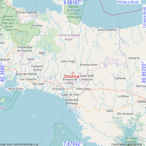
Chichica GPS coordinates[2]
8° 22' 0.012" North, 81° 40' 0.012" West
| Map corner | latitude | longitude |
|---|---|---|
| Upper-left | 9.06167°, | -82.3698° |
| Center: | 8.36667°, | -81.66667° |
| Lower-right: | 7.67042°, | -80.96355° |
| Map W x H: | 154.7×154.7 km | = 96.1×96.1mi |
| max Lat: | 9.60898° ⇑61.1% North |
| Chichica: | 8.36667° |
| min Lat: | ⇓38.9% South 7.26534° |
| min Long | Chichica | max Long |
| -82.91275° | -81.66667° | -77.38965° |
| W 27.7%⇐ | ⇒72.3% E |
Elevation
Elevation of Chichica is 519 m = 1703 ft, and this is 346.9 m = 1138 ft above average elevation for this country.
| Max E: |
2103 m = 6900 ft | 7.2% |
| Chichica | 519 m 1703 ft | |
| Avg. | 172.1 m = 565 ft | |
Min E: |
-1 m = -3 ft | 92.8% |
See also: Panama elevation on elevation.city.
Geographical zone
Chichica is located in North Torrid zone (between Equator and Tropic of Cancer). Distance of Equator is 930.3 km =578.1 mi to South.| Distance of | km | miles | from Chichica |
|---|---|---|---|
| North Pole | 9076.8 | 5640.1 | to North |
| Arctic Circle | 6470.9 | 4020.8 | to North |
| Tropic Cancer | 1675.6 | 1041.2 | to North |
| Equator | 930.3 | 578.1 | to South |


Nearby cities:
15 places around Chichica: (largest is in red/bold)
• Alto Caballero
8.6 km =5.3 mi,  185°
185°
• Cabecera de Cerro Puerco
11.5 km =7.1 mi,  242°
242°
• Cerro Caña
6.4 km =4 mi,  105°
105°
• Cerro Ceniza
11.3 km =7 mi,  256°
256°
• Cerro Iglesias
12.5 km =7.8 mi,  115°
115°
• Cerro Mosquito
3.3 km =2.1 mi,  229°
229°
• Chichica
0.9 km =0.6 mi,  173°
173°
• Llano Junco
9.8 km =6.1 mi, 261°
• Llano Ñopo
7.9 km =4.9 mi,  41°
41°
• Maraca
6.7 km =4.2 mi,  276°
276°
• Peña Blanca
10.7 km =6.6 mi,  352°
352°
• Peña Prieta
5.6 km =3.5 mi,  274°
274°
• Potrero de Caña
8.9 km =5.5 mi,  203°
203°
• Sitio Prado
9.4 km =5.8 mi,  86°
86°
• Tebujo
6.5 km =4 mi,  291°
291°
Sources, notices
• [Note1] Compared only with cities in Panama existing in our database
• [Src1] Map data: © OpenStreetMap contributors (CC-BY-SA)
• [Src2] Other city data from geonames.org with taken over terms of usage.
• [Src3] Geographical zone / Annual Mean Temperature by Robert A. Rohde @ Wikipedia
