Gonzalillo geodata
Gonzalillo (Panamá) is a section of populated place; located in Panama in America/Panama (GMT-5) time zone. With population of 7,793 people, there are 51 cities with bigger population in this country. Compared to other cities in Panama, 86.9% of cities are located further ↓South; 87.4% of cities are located further ←West and 50.9% of cities have higher elevation than Gonzalillo. Note1


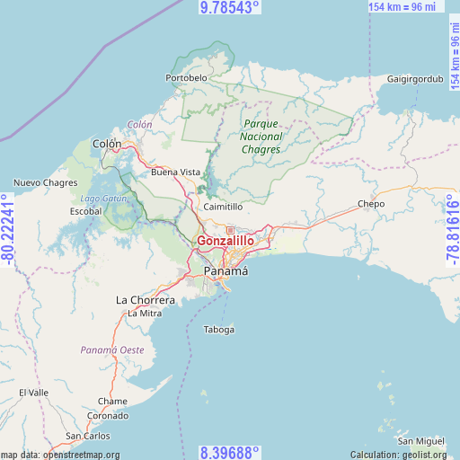
Gonzalillo GPS coordinates[2]
9° 5' 30.588" North, 79° 31' 9.408" West
| Map corner | latitude | longitude |
|---|---|---|
| Upper-left | 9.78543°, | -80.22241° |
| Center: | 9.09183°, | -79.51928° |
| Lower-right: | 8.39688°, | -78.81616° |
| Map W x H: | 154.4×154.4 km | = 95.9×95.9mi |
| max Lat: | 9.60898° ⇑13.1% North |
| Gonzalillo: | 9.09183° |
| min Lat: | ⇓86.9% South 7.26534° |
| min Long | Gonzalillo | max Long |
| -82.91275° | -79.51928° | -77.38965° |
| W 87.4%⇐ | ⇒12.6% E |
Elevation
Elevation of Gonzalillo is 70 m = 230 ft, and this is 102.1 m = 335 ft below average elevation for this country.
| Max E: |
2103 m = 6900 ft | 50.9% |
| Avg. | 172.1 m = 565 ft | |
| Gonzalillo | 70 m = 230 ft | |
Min E: |
-1 m = -3 ft | 49.1% |
See also: Panama elevation on elevation.city.
Geographical zone
Gonzalillo is located in North Torrid zone (between Equator and Tropic of Cancer). Distance of Equator is 1010.9 km =628.1 mi to South.| Distance of | km | miles | from Gonzalillo |
|---|---|---|---|
| North Pole | 8996.1 | 5589.9 | to North |
| Arctic Circle | 6390.3 | 3970.7 | to North |
| Tropic Cancer | 1595 | 991.1 | to North |
| Equator | 1010.9 | 628.1 | to South |


Nearby cities:
15 places around Gonzalillo: (largest is in red/bold)
• Alcalde Díaz
5.2 km =3.2 mi,  307°
307°
• Caimitillo
7.4 km =4.6 mi,  342°
342°
• Calzada Larga
10.1 km =6.3 mi,  332°
332°
• Juan Díaz
8.9 km =5.5 mi,  121°
121°
• La Cabima
3.5 km =2.2 mi, 327°
• La Colorada
11.4 km =7.1 mi,  84°
84°
• Las Cumbres
1 km =0.6 mi,  252°
252°
• Mocambo Arriba
5.6 km =3.5 mi, 249°
• Panamá
10.9 km =6.8 mi,  180°
180°
• Parque Lefevre
9.2 km =5.7 mi,  154°
154°
• Pedregal
9.8 km =6.1 mi,  106°
106°
• Río Abajo
8.6 km =5.3 mi,  165°
165°
• San Antonio
9.5 km =5.9 mi, 341°
• San Miguelito
7.1 km =4.4 mi,  130°
130°
• San Vicente
9 km =5.6 mi,  286°
286°
Sources, notices
• [Note1] Compared only with cities in Panama existing in our database
• [Src1] Map data: © OpenStreetMap contributors (CC-BY-SA)
• [Src2] Other city data from geonames.org with taken over terms of usage.
• [Src3] Geographical zone / Annual Mean Temperature by Robert A. Rohde @ Wikipedia
