Parque Lefevre geodata
Parque Lefevre (Panamá) is a section of populated place; located in Panama in America/Panama (GMT-5) time zone. With population of 36,997 people, there are 11 cities with bigger population in this country. Compared to other cities in Panama, 84.1% of cities are located further ↓South; 87.7% of cities are located further ←West and 94.7% of cities have higher elevation than Parque Lefevre. Note1


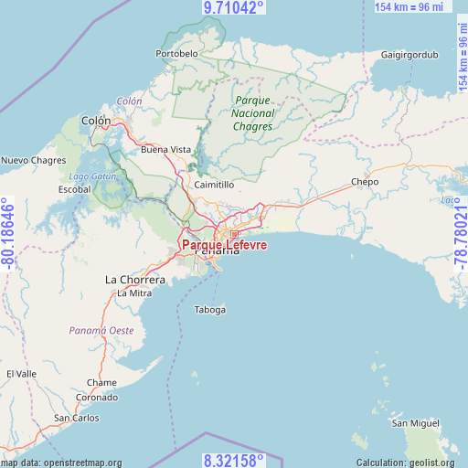
Parque Lefevre GPS coordinates[2]
9° 1' 0.012" North, 79° 28' 59.988" West
| Map corner | latitude | longitude |
|---|---|---|
| Upper-left | 9.71042°, | -80.18646° |
| Center: | 9.01667°, | -79.48333° |
| Lower-right: | 8.32158°, | -78.78021° |
| Map W x H: | 154.4×154.4 km | = 95.9×95.9mi |
| max Lat: | 9.60898° ⇑15.9% North |
| Parque Lefevre: | 9.01667° |
| min Lat: | ⇓84.1% South 7.26534° |
| min Long | Parque Lefevre | max Long |
| -82.91275° | -79.48333° | -77.38965° |
| W 87.7%⇐ | ⇒12.3% E |
Elevation
Elevation of Parque Lefevre is 8 m = 26 ft, and this is 164.1 m = 538 ft below average elevation for this country.
| Max E: |
2103 m = 6900 ft | 94.7% |
| Avg. | 172.1 m = 565 ft | |
| Parque Lefevre | 8 m = 26 ft | |
Min E: |
-1 m = -3 ft | 5.3% |
See also: Panama elevation on elevation.city.
Geographical zone
Parque Lefevre is located in North Torrid zone (between Equator and Tropic of Cancer). Distance of Equator is 1002.6 km =623 mi to South.| Distance of | km | miles | from Parque Lefevre |
|---|---|---|---|
| North Pole | 9004.5 | 5595.1 | to North |
| Arctic Circle | 6398.6 | 3975.9 | to North |
| Tropic Cancer | 1603.4 | 996.3 | to North |
| Equator | 1002.6 | 623 | to South |


Nearby cities:
15 places around Parque Lefevre: (largest is in red/bold)
• Ancón
9.8 km =6.1 mi,  229°
229°
• Balboa
11.9 km =7.4 mi, 230°
• Curundú
8.6 km =5.3 mi, 233°
• El Chorrillo
10.2 km =6.3 mi,  223°
223°
• Gonzalillo
9.2 km =5.7 mi,  334°
334°
• Juan Díaz
5.2 km =3.2 mi,  44°
44°
• La Colorada
12 km =7.5 mi, 37°
• Las Cumbres
9.4 km =5.8 mi, 328°
• Mocambo Arriba
11.2 km =7 mi,  304°
304°
• Nuevo Belén
11.9 km =7.4 mi,  54°
54°
• Panamá
4.7 km =2.9 mi,  237°
237°
• Pedregal
7.8 km =4.8 mi, 44°
• Río Abajo
1.8 km =1.1 mi,  270°
270°
• San Felipe
9.4 km =5.8 mi, 219°
• San Miguelito
4 km =2.5 mi,  20°
20°
Sources, notices
• [Note1] Compared only with cities in Panama existing in our database
• [Src1] Map data: © OpenStreetMap contributors (CC-BY-SA)
• [Src2] Other city data from geonames.org with taken over terms of usage.
• [Src3] Geographical zone / Annual Mean Temperature by Robert A. Rohde @ Wikipedia
