La Mesa geodata
La Mesa (Bocas del Toro) is a populated place; located in Panama in America/Panama (GMT-5) time zone. With population of 1,235 people, there are 197 cities with bigger population in this country. Compared to other cities in Panama, 98.1% of cities are located further ↓South; 93.6% of cities are located further →East and 86.3% of cities have higher elevation than La Mesa. Note1


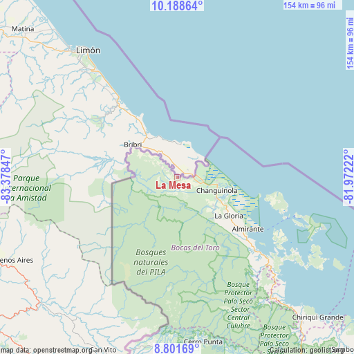
La Mesa GPS coordinates[2]
9° 29' 45.132" North, 82° 40' 31.224" West
| Map corner | latitude | longitude |
|---|---|---|
| Upper-left | 10.18864°, | -83.37847° |
| Center: | 9.49587°, | -82.67534° |
| Lower-right: | 8.80169°, | -81.97222° |
| Map W x H: | 154.2×154.2 km | = 95.8×95.8mi |
| max Lat: | 9.60898° ⇑1.9% North |
| La Mesa: | 9.49587° |
| min Lat: | ⇓98.1% South 7.26534° |
| min Long | La Mesa | max Long |
| -82.91275° | -82.67534° | -77.38965° |
| W 6.4%⇐ | ⇒93.6% E |
Elevation
Elevation of La Mesa is 16 m = 52 ft, and this is 156.1 m = 512 ft below average elevation for this country.
| Max E: |
2103 m = 6900 ft | 86.3% |
| Avg. | 172.1 m = 565 ft | |
| La Mesa | 16 m = 52 ft | |
Min E: |
-1 m = -3 ft | 13.7% |
See also: Panama elevation on elevation.city.
Geographical zone
La Mesa is located in North Torrid zone (between Equator and Tropic of Cancer). Distance of Equator is 1055.8 km =656 mi to South.| Distance of | km | miles | from La Mesa |
|---|---|---|---|
| North Pole | 8951.2 | 5562 | to North |
| Arctic Circle | 6345.3 | 3942.8 | to North |
| Tropic Cancer | 1550.1 | 963.2 | to North |
| Equator | 1055.8 | 656 | to South |


Nearby cities:
15 places around La Mesa: (largest is in red/bold)
• Almirante
37 km =23 mi,  125°
125°
• Barranco
4.1 km =2.5 mi,  310°
310°
• Barranco Adentro
7.3 km =4.5 mi,  298°
298°
• Bastimentos
53.8 km =33.4 mi,  107°
107°
• Bocas del Toro
50.6 km =31.4 mi, 109°
• Cauchero
59.1 km =36.7 mi, 130°
• Changuinola
18.5 km =11.5 mi, 113°
• El Empalme
19.5 km =12.1 mi,  116°
116°
• El Silencio
21.2 km =13.2 mi, 130°
• Guabito
6.9 km =4.3 mi,  95°
95°
• Nuevo Paraiso
37.6 km =23.4 mi, 129°
• Quebrada Pastor
46.9 km =29.1 mi, 132°
• San Cristóbal
50.7 km =31.5 mi, 118°
• Sieyic
12.8 km =8 mi,  168°
168°
• Valle del Risco
40.1 km =24.9 mi,  137°
137°
Sources, notices
• [Note1] Compared only with cities in Panama existing in our database
• [Src1] Map data: © OpenStreetMap contributors (CC-BY-SA)
• [Src2] Other city data from geonames.org with taken over terms of usage.
• [Src3] Geographical zone / Annual Mean Temperature by Robert A. Rohde @ Wikipedia
