Bastimentos geodata
Bastimentos (Bocas del Toro) is a seat of a third-order administrative division; located in Panama in America/Panama (GMT-5) time zone. With population of 738 people, there are 342 cities with bigger population in this country. Compared to other cities in Panama, 96.1% of cities are located further ↓South; 80.9% of cities are located further →East and 82.5% of cities have higher elevation than Bastimentos. Note1


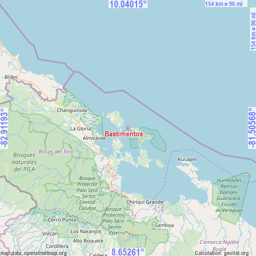
Bastimentos GPS coordinates[2]
9° 20' 49.452" North, 82° 12' 31.68" West
| Map corner | latitude | longitude |
|---|---|---|
| Upper-left | 10.04015°, | -82.91193° |
| Center: | 9.34707°, | -82.2088° |
| Lower-right: | 8.65261°, | -81.50568° |
| Map W x H: | 154.3×154.3 km | = 95.9×95.9mi |
| max Lat: | 9.60898° ⇑3.9% North |
| Bastimentos: | 9.34707° |
| min Lat: | ⇓96.1% South 7.26534° |
| min Long | Bastimentos | max Long |
| -82.91275° | -82.2088° | -77.38965° |
| W 19.1%⇐ | ⇒80.9% E |
Elevation
Elevation of Bastimentos is 20 m = 66 ft, and this is 152.1 m = 499 ft below average elevation for this country.
| Max E: |
2103 m = 6900 ft | 82.5% |
| Avg. | 172.1 m = 565 ft | |
| Bastimentos | 20 m = 66 ft | |
Min E: |
-1 m = -3 ft | 17.5% |
See also: Panama elevation on elevation.city.
Geographical zone
Bastimentos is located in North Torrid zone (between Equator and Tropic of Cancer). Distance of Equator is 1039.3 km =645.8 mi to South.| Distance of | km | miles | from Bastimentos |
|---|---|---|---|
| North Pole | 8967.8 | 5572.3 | to North |
| Arctic Circle | 6361.9 | 3953.1 | to North |
| Tropic Cancer | 1566.6 | 973.4 | to North |
| Equator | 1039.3 | 645.8 | to South |


Nearby cities:
15 places around Bastimentos: (largest is in red/bold)
• Almirante
21.8 km =13.5 mi,  256°
256°
• Bocas del Toro
3.7 km =2.3 mi, 258°
• Cauchero
22.5 km =14 mi,  195°
195°
• Cayo de Agua
27.6 km =17.1 mi,  142°
142°
• Changuinola
35.4 km =22 mi,  285°
285°
• El Empalme
34.6 km =21.5 mi,  282°
282°
• El Silencio
35.2 km =21.9 mi,  274°
274°
• Isla Bastimentos
9.8 km =6.1 mi,  122°
122°
• Isla Tigre
23.8 km =14.8 mi, 143°
• Nuevo Paraiso
23.4 km =14.5 mi,  251°
251°
• Punta Laurel
24.6 km =15.3 mi,  158°
158°
• Punta Róbalo
34.8 km =21.6 mi,  187°
187°
• Quebrada Pastor
22.6 km =14 mi,  227°
227°
• San Cristóbal
9.8 km =6.1 mi,  221°
221°
• Valle del Risco
27.3 km =17 mi,  241°
241°
Sources, notices
• [Note1] Compared only with cities in Panama existing in our database
• [Src1] Map data: © OpenStreetMap contributors (CC-BY-SA)
• [Src2] Other city data from geonames.org with taken over terms of usage.
• [Src3] Geographical zone / Annual Mean Temperature by Robert A. Rohde @ Wikipedia
