Almirante geodata
Almirante (Bocas del Toro) is a populated place; located in Panama in America/Panama (GMT-5) time zone. With population of 8,744 people, there are 46 cities with bigger population in this country. Compared to other cities in Panama, 95% of cities are located further ↓South; 84.3% of cities are located further →East and 93.8% of cities have higher elevation than Almirante. Note1


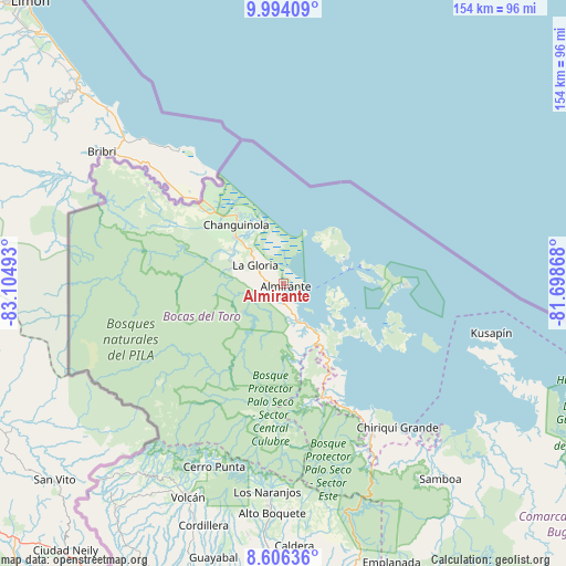
Almirante GPS coordinates[2]
9° 18' 3.276" North, 82° 24' 6.48" West
| Map corner | latitude | longitude |
|---|---|---|
| Upper-left | 9.99409°, | -83.10493° |
| Center: | 9.30091°, | -82.4018° |
| Lower-right: | 8.60636°, | -81.69868° |
| Map W x H: | 154.3×154.3 km | = 95.9×95.9mi |
| max Lat: | 9.60898° ⇑5% North |
| Almirante: | 9.30091° |
| min Lat: | ⇓95% South 7.26534° |
| min Long | Almirante | max Long |
| -82.91275° | -82.4018° | -77.38965° |
| W 15.7%⇐ | ⇒84.3% E |
Elevation
Elevation of Almirante is 9 m = 30 ft, and this is 163.1 m = 535 ft below average elevation for this country.
| Max E: |
2103 m = 6900 ft | 93.8% |
| Avg. | 172.1 m = 565 ft | |
| Almirante | 9 m = 30 ft | |
Min E: |
-1 m = -3 ft | 6.2% |
See also: Panama elevation on elevation.city.
Geographical zone
Almirante is located in North Torrid zone (between Equator and Tropic of Cancer). Distance of Equator is 1034.2 km =642.6 mi to South.| Distance of | km | miles | from Almirante |
|---|---|---|---|
| North Pole | 8972.9 | 5575.5 | to North |
| Arctic Circle | 6367 | 3956.3 | to North |
| Tropic Cancer | 1571.8 | 976.7 | to North |
| Equator | 1034.2 | 642.6 | to South |


Nearby cities:
15 places around Almirante: (largest is in red/bold)
• Bastimentos
21.8 km =13.5 mi,  76°
76°
• Bocas del Toro
18.1 km =11.2 mi, 75°
• Cauchero
22.4 km =13.9 mi,  137°
137°
• Changuinola
19.3 km =12 mi,  317°
317°
• El Empalme
18 km =11.2 mi, 315°
• El Silencio
16 km =9.9 mi,  299°
299°
• Guabito
31.2 km =19.4 mi,  312°
312°
• Isla Bastimentos
29.5 km =18.3 mi,  90°
90°
• Norteño
34.5 km =21.4 mi,  163°
163°
• Nuevo Paraiso
2.5 km =1.6 mi,  205°
205°
• Punta Róbalo
33.8 km =21 mi,  150°
150°
• Quebrada Pastor
11.1 km =6.9 mi, 155°
• San Cristóbal
14.9 km =9.3 mi,  98°
98°
• Sieyic
28.9 km =18 mi,  288°
288°
• Valle del Risco
8.3 km =5.2 mi,  199°
199°
Sources, notices
• [Note1] Compared only with cities in Panama existing in our database
• [Src1] Map data: © OpenStreetMap contributors (CC-BY-SA)
• [Src2] Other city data from geonames.org with taken over terms of usage.
• [Src3] Geographical zone / Annual Mean Temperature by Robert A. Rohde @ Wikipedia
