Cauchero geodata
Cauchero (Bocas del Toro) is a seat of a third-order administrative division; located in Panama in America/Panama (GMT-5) time zone. With population of 40 people, there are 687 cities with bigger population in this country. Compared to other cities in Panama, 89.4% of cities are located further ↓South; 81.9% of cities are located further →East and 61.3% of cities have higher elevation than Cauchero. Note1


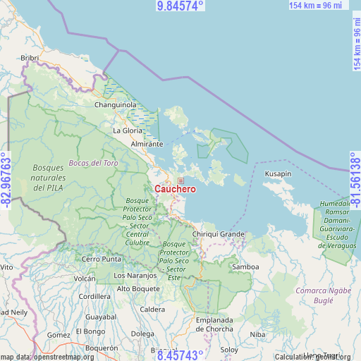
Cauchero GPS coordinates[2]
9° 9' 8.136" North, 82° 15' 52.2" West
| Map corner | latitude | longitude |
|---|---|---|
| Upper-left | 9.84574°, | -82.96763° |
| Center: | 9.15226°, | -82.2645° |
| Lower-right: | 8.45743°, | -81.56138° |
| Map W x H: | 154.4×154.4 km | = 95.9×95.9mi |
| max Lat: | 9.60898° ⇑10.6% North |
| Cauchero: | 9.15226° |
| min Lat: | ⇓89.4% South 7.26534° |
| min Long | Cauchero | max Long |
| -82.91275° | -82.2645° | -77.38965° |
| W 18.1%⇐ | ⇒81.9% E |
Elevation
Elevation of Cauchero is 50 m = 164 ft, and this is 122.1 m = 401 ft below average elevation for this country.
| Max E: |
2103 m = 6900 ft | 61.3% |
| Avg. | 172.1 m = 565 ft | |
| Cauchero | 50 m = 164 ft | |
Min E: |
-1 m = -3 ft | 38.7% |
See also: Panama elevation on elevation.city.
Geographical zone
Cauchero is located in North Torrid zone (between Equator and Tropic of Cancer). Distance of Equator is 1017.6 km =632.3 mi to South.| Distance of | km | miles | from Cauchero |
|---|---|---|---|
| North Pole | 8989.4 | 5585.8 | to North |
| Arctic Circle | 6383.5 | 3966.5 | to North |
| Tropic Cancer | 1588.3 | 986.9 | to North |
| Equator | 1017.6 | 632.3 | to South |


Nearby cities:
15 places around Cauchero: (largest is in red/bold)
• Almirante
22.4 km =13.9 mi,  317°
317°
• Bastimentos
22.5 km =14 mi,  15°
15°
• Bocas del Toro
21.1 km =13.1 mi,  6°
6°
• Cayo de Agua
22.9 km =14.2 mi,  90°
90°
• Isla Bastimentos
21.8 km =13.5 mi,  41°
41°
• Isla Tigre
20.4 km =12.7 mi,  82°
82°
• Los Chiricanos
20.1 km =12.5 mi,  164°
164°
• Miramar
17.7 km =11 mi,  171°
171°
• Norteño
17.5 km =10.9 mi,  198°
198°
• Nuevo Paraiso
21.5 km =13.4 mi,  311°
311°
• Punta Laurel
15.1 km =9.4 mi, 94°
• Punta Róbalo
13 km =8.1 mi, 172°
• Quebrada Pastor
12.4 km =7.7 mi,  301°
301°
• San Cristóbal
14.4 km =8.9 mi,  358°
358°
• Valle del Risco
19.9 km =12.4 mi, 295°
Sources, notices
• [Note1] Compared only with cities in Panama existing in our database
• [Src1] Map data: © OpenStreetMap contributors (CC-BY-SA)
• [Src2] Other city data from geonames.org with taken over terms of usage.
• [Src3] Geographical zone / Annual Mean Temperature by Robert A. Rohde @ Wikipedia
