San Cristóbal geodata
San Cristóbal (Bocas del Toro) is a populated place; located in Panama in America/Panama (GMT-5) time zone. With population of 525 people, there are 467 cities with bigger population in this country. Compared to other cities in Panama, 94.2% of cities are located further ↓South; 82% of cities are located further →East and 92.8% of cities have higher elevation than San Cristóbal. Note1


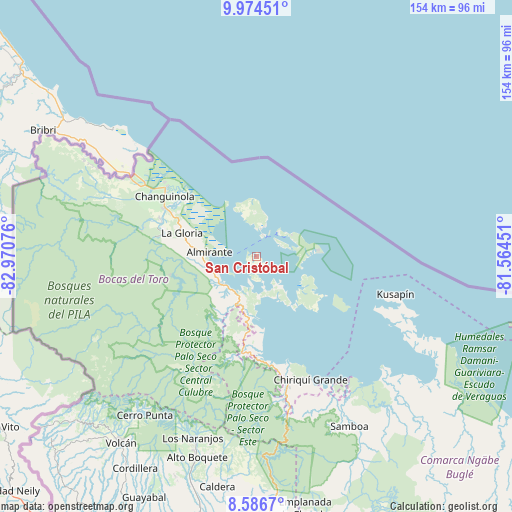
San Cristóbal GPS coordinates[2]
9° 16' 52.644" North, 82° 16' 3.468" West
| Map corner | latitude | longitude |
|---|---|---|
| Upper-left | 9.97451°, | -82.97076° |
| Center: | 9.28129°, | -82.26763° |
| Lower-right: | 8.5867°, | -81.56451° |
| Map W x H: | 154.3×154.3 km | = 95.9×95.9mi |
| max Lat: | 9.60898° ⇑5.8% North |
| San Cristóbal: | 9.28129° |
| min Lat: | ⇓94.2% South 7.26534° |
| min Long | San Cristóbal | max Long |
| -82.91275° | -82.26763° | -77.38965° |
| W 18%⇐ | ⇒82% E |
Elevation
Elevation of San Cristóbal is 10 m = 33 ft, and this is 162.1 m = 532 ft below average elevation for this country.
| Max E: |
2103 m = 6900 ft | 92.8% |
| Avg. | 172.1 m = 565 ft | |
| San Cristóbal | 10 m = 33 ft | |
Min E: |
-1 m = -3 ft | 7.2% |
See also: Panama elevation on elevation.city.
Geographical zone
San Cristóbal is located in North Torrid zone (between Equator and Tropic of Cancer). Distance of Equator is 1032 km =641.3 mi to South.| Distance of | km | miles | from San Cristóbal |
|---|---|---|---|
| North Pole | 8975.1 | 5576.9 | to North |
| Arctic Circle | 6369.2 | 3957.6 | to North |
| Tropic Cancer | 1573.9 | 978 | to North |
| Equator | 1032 | 641.3 | to South |


Nearby cities:
15 places around San Cristóbal: (largest is in red/bold)
• Almirante
14.9 km =9.3 mi,  278°
278°
• Bastimentos
9.8 km =6.1 mi,  41°
41°
• Bocas del Toro
7.1 km =4.4 mi,  23°
23°
• Cauchero
14.4 km =8.9 mi,  178°
178°
• Cayo de Agua
27.5 km =17.1 mi,  122°
122°
• El Empalme
31.2 km =19.4 mi,  298°
298°
• El Silencio
30.4 km =18.9 mi,  289°
289°
• Isla Bastimentos
14.9 km =9.3 mi,  81°
81°
• Isla Tigre
23.7 km =14.7 mi, 119°
• Norteño
31.4 km =19.5 mi,  189°
189°
• Nuevo Paraiso
15.8 km =9.8 mi,  269°
269°
• Punta Laurel
21.9 km =13.6 mi,  135°
135°
• Punta Róbalo
27.3 km =17 mi, 175°
• Quebrada Pastor
12.9 km =8 mi,  232°
232°
• Valle del Risco
18.4 km =11.4 mi,  252°
252°
Sources, notices
• [Note1] Compared only with cities in Panama existing in our database
• [Src1] Map data: © OpenStreetMap contributors (CC-BY-SA)
• [Src2] Other city data from geonames.org with taken over terms of usage.
• [Src3] Geographical zone / Annual Mean Temperature by Robert A. Rohde @ Wikipedia
