Manaca Civil geodata
Manaca Civil (Chiriquí) is a populated place; located in Panama in America/Panama (GMT-5) time zone. With population of 1,220 people, there are 200 cities with bigger population in this country. Compared to other cities in Panama, 64.9% of cities are located further ↑North; 97% of cities are located further →East and 88.9% of cities have higher elevation than Manaca Civil. Note1


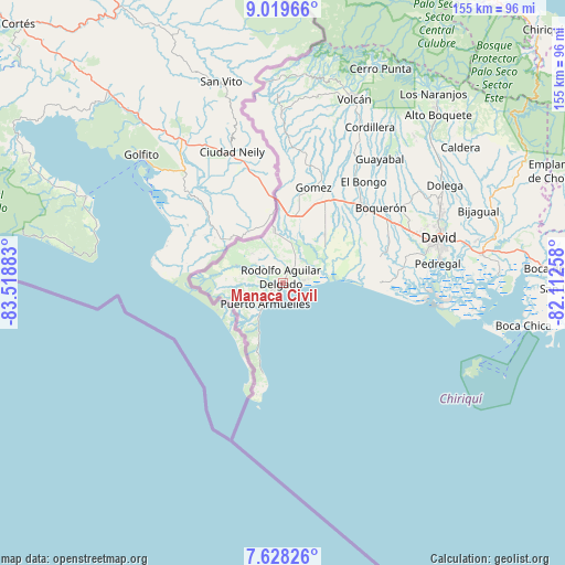
Manaca Civil GPS coordinates[2]
8° 19' 28.488" North, 82° 48' 56.52" West
| Map corner | latitude | longitude |
|---|---|---|
| Upper-left | 9.01966°, | -83.51883° |
| Center: | 8.32458°, | -82.8157° |
| Lower-right: | 7.62826°, | -82.11258° |
| Map W x H: | 154.7×154.7 km | = 96.1×96.1mi |
| max Lat: | 9.60898° ⇑64.9% North |
| Manaca Civil: | 8.32458° |
| min Lat: | ⇓35.1% South 7.26534° |
| min Long | Manaca Civil | max Long |
| -82.91275° | -82.8157° | -77.38965° |
| W 3%⇐ | ⇒97% E |
Elevation
Elevation of Manaca Civil is 13 m = 43 ft, and this is 159.1 m = 522 ft below average elevation for this country.
| Max E: |
2103 m = 6900 ft | 88.9% |
| Avg. | 172.1 m = 565 ft | |
| Manaca Civil | 13 m = 43 ft | |
Min E: |
-1 m = -3 ft | 11.1% |
See also: Panama elevation on elevation.city.
Geographical zone
Manaca Civil is located in North Torrid zone (between Equator and Tropic of Cancer). Distance of Equator is 925.6 km =575.1 mi to South.| Distance of | km | miles | from Manaca Civil |
|---|---|---|---|
| North Pole | 9081.5 | 5643 | to North |
| Arctic Circle | 6475.6 | 4023.8 | to North |
| Tropic Cancer | 1680.3 | 1044.1 | to North |
| Equator | 925.6 | 575.1 | to South |


Nearby cities:
15 places around Manaca Civil: (largest is in red/bold)
• Agua Buena
6.8 km =4.2 mi,  246°
246°
• Berba
6.7 km =4.2 mi,  2°
2°
• Chuchupate
13.3 km =8.3 mi,  336°
336°
• El Palmar
4.9 km =3 mi,  237°
237°
• Finca Blanco
8.9 km =5.5 mi,  313°
313°
• Finca Corredor
6.7 km =4.2 mi,  287°
287°
• La Esperanza
9.1 km =5.7 mi,  16°
16°
• Majagual
5.5 km =3.4 mi,  73°
73°
• Manaca Norte
1.2 km =0.7 mi,  30°
30°
• Monte Verde
8.4 km =5.2 mi,  228°
228°
• Progreso
13.8 km =8.6 mi,  349°
349°
• Puerto Armuelles
7.3 km =4.5 mi,  224°
224°
• San Bartolo Línea
7.3 km =4.5 mi,  260°
260°
• San Valentín
6.2 km =3.9 mi,  39°
39°
• Santa María
14 km =8.7 mi, 347°
Sources, notices
• [Note1] Compared only with cities in Panama existing in our database
• [Src1] Map data: © OpenStreetMap contributors (CC-BY-SA)
• [Src2] Other city data from geonames.org with taken over terms of usage.
• [Src3] Geographical zone / Annual Mean Temperature by Robert A. Rohde @ Wikipedia
