Monte Verde geodata
Monte Verde (Chiriquí) is a populated place; located in Panama in America/Panama (GMT-5) time zone. With population of 528 people, there are 464 cities with bigger population in this country. Compared to other cities in Panama, 68.3% of cities are located further ↑North; 99.2% of cities are located further →East and 62.1% of cities have higher elevation than Monte Verde. Note1


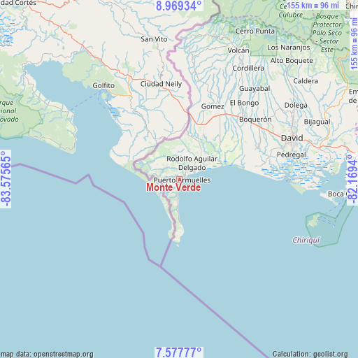
Monte Verde GPS coordinates[2]
8° 16' 27.012" North, 82° 52' 21.072" West
| Map corner | latitude | longitude |
|---|---|---|
| Upper-left | 8.96934°, | -83.57565° |
| Center: | 8.27417°, | -82.87252° |
| Lower-right: | 7.57777°, | -82.1694° |
| Map W x H: | 154.7×154.7 km | = 96.1×96.1mi |
| max Lat: | 9.60898° ⇑68.3% North |
| Monte Verde: | 8.27417° |
| min Lat: | ⇓31.7% South 7.26534° |
| min Long | Monte Verde | max Long |
| -82.91275° | -82.87252° | -77.38965° |
| W 0.8%⇐ | ⇒99.2% E |
Elevation
Elevation of Monte Verde is 49 m = 161 ft, and this is 123.1 m = 404 ft below average elevation for this country.
| Max E: |
2103 m = 6900 ft | 62.1% |
| Avg. | 172.1 m = 565 ft | |
| Monte Verde | 49 m = 161 ft | |
Min E: |
-1 m = -3 ft | 37.9% |
See also: Panama elevation on elevation.city.
Geographical zone
Monte Verde is located in North Torrid zone (between Equator and Tropic of Cancer). Distance of Equator is 920 km =571.7 mi to South.| Distance of | km | miles | from Monte Verde |
|---|---|---|---|
| North Pole | 9087.1 | 5646.5 | to North |
| Arctic Circle | 6481.2 | 4027.2 | to North |
| Tropic Cancer | 1685.9 | 1047.6 | to North |
| Equator | 920 | 571.7 | to South |


Nearby cities:
15 places around Monte Verde: (largest is in red/bold)
• Agua Buena
2.9 km =1.8 mi,  1°
1°
• Berba
13.9 km =8.6 mi,  27°
27°
• Chuchupate
17.9 km =11.1 mi, 2°
• El Palmar
3.6 km =2.2 mi,  35°
35°
• Finca Balsa
17.4 km =10.8 mi,  351°
351°
• Finca Blanco
11.7 km =7.3 mi,  359°
359°
• Finca Corredor
7.6 km =4.7 mi, 359°
• La Esperanza
16.9 km =10.5 mi, 31°
• Limones
19.4 km =12.1 mi,  178°
178°
• Majagual
13.6 km =8.5 mi,  57°
57°
• Manaca Civil
8.4 km =5.2 mi,  48°
48°
• Manaca Norte
9.6 km =6 mi, 45°
• Puerto Armuelles
1.2 km =0.7 mi,  70°
70°
• San Bartolo Línea
4.5 km =2.8 mi, 348°
• San Valentín
14.5 km =9 mi, 44°
Sources, notices
• [Note1] Compared only with cities in Panama existing in our database
• [Src1] Map data: © OpenStreetMap contributors (CC-BY-SA)
• [Src2] Other city data from geonames.org with taken over terms of usage.
• [Src3] Geographical zone / Annual Mean Temperature by Robert A. Rohde @ Wikipedia
