Majagual geodata
Majagual (Chiriquí) is a populated place; located in Panama in America/Panama (GMT-5) time zone. With population of 521 people, there are 471 cities with bigger population in this country. Compared to other cities in Panama, 64.2% of cities are located further ↑North; 95.5% of cities are located further →East and 96.3% of cities have higher elevation than Majagual. Note1


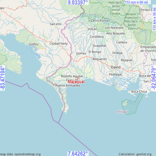
Majagual GPS coordinates[2]
8° 20' 20.076" North, 82° 46' 4.476" West
| Map corner | latitude | longitude |
|---|---|---|
| Upper-left | 9.03397°, | -83.47104° |
| Center: | 8.33891°, | -82.76791° |
| Lower-right: | 7.64262°, | -82.06479° |
| Map W x H: | 154.7×154.7 km | = 96.1×96.1mi |
| max Lat: | 9.60898° ⇑64.2% North |
| Majagual: | 8.33891° |
| min Lat: | ⇓35.8% South 7.26534° |
| min Long | Majagual | max Long |
| -82.91275° | -82.76791° | -77.38965° |
| W 4.5%⇐ | ⇒95.5% E |
Elevation
Elevation of Majagual is 6 m = 20 ft, and this is 166.1 m = 545 ft below average elevation for this country.
| Max E: |
2103 m = 6900 ft | 96.3% |
| Avg. | 172.1 m = 565 ft | |
| Majagual | 6 m = 20 ft | |
Min E: |
-1 m = -3 ft | 3.7% |
See also: Panama elevation on elevation.city.
Geographical zone
Majagual is located in North Torrid zone (between Equator and Tropic of Cancer). Distance of Equator is 927.2 km =576.1 mi to South.| Distance of | km | miles | from Majagual |
|---|---|---|---|
| North Pole | 9079.9 | 5642 | to North |
| Arctic Circle | 6474 | 4022.8 | to North |
| Tropic Cancer | 1678.7 | 1043.1 | to North |
| Equator | 927.2 | 576.1 | to South |


Nearby cities:
15 places around Majagual: (largest is in red/bold)
• Agua Buena
12.2 km =7.6 mi,  249°
249°
• Berba
7.1 km =4.4 mi,  315°
315°
• Divalá
10 km =6.2 mi,  36°
36°
• El Palmar
10.3 km =6.4 mi, 245°
• Finca Blanco
12.5 km =7.8 mi,  291°
291°
• Finca Corredor
11.6 km =7.2 mi,  272°
272°
• La Esperanza
7.6 km =4.7 mi,  339°
339°
• Manaca Civil
5.5 km =3.4 mi, 253°
• Manaca Norte
4.7 km =2.9 mi,  263°
263°
• Monte Verde
13.6 km =8.5 mi,  237°
237°
• Progreso
14.3 km =8.9 mi,  327°
327°
• Puerto Armuelles
12.4 km =7.7 mi, 236°
• San Bartolo Línea
12.7 km =7.9 mi, 257°
• San Valentín
3.4 km =2.1 mi, 337°
• Santo Tomás
14.1 km =8.8 mi,  66°
66°
Sources, notices
• [Note1] Compared only with cities in Panama existing in our database
• [Src1] Map data: © OpenStreetMap contributors (CC-BY-SA)
• [Src2] Other city data from geonames.org with taken over terms of usage.
• [Src3] Geographical zone / Annual Mean Temperature by Robert A. Rohde @ Wikipedia
