Tambo Grande geodata
Tambo Grande (Piura) is a seat of a third-order administrative division; located in Peru in America/Lima (GMT-5) time zone. With population of 30,033 people, there are 57 cities with bigger population in this country. Compared to other cities in Peru, 95.7% of cities are located further ↓South; 97.3% of cities are located further →East and 91.6% of cities have higher elevation than Tambo Grande. Note1


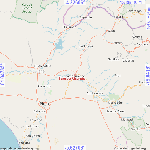
Tambo Grande GPS coordinates[2]
4° 55' 36.984" South, 80° 20' 40.992" West
| Map corner | latitude | longitude |
|---|---|---|
| Upper-left | -4.22606°, | -81.04785° |
| Center: | -4.92694°, | -80.34472° |
| Lower-right: | -5.62708°, | -79.6416° |
| Map W x H: | 155.8×155.8 km | = 96.8×96.8mi |
| max Lat: | -0.96667° ⇑4.3% North |
| Tambo Grande: | -4.92694° |
| min Lat: | ⇓95.7% South -18.01465° |
| min Long | Tambo Grande | max Long |
| -81.30472° | -80.34472° | -69.04167° |
| W 2.7%⇐ | ⇒97.3% E |
Elevation
Elevation of Tambo Grande is 69 m = 226 ft, and this is 2249.7 m = 7381 ft below average elevation for this country.
| Max E: |
5022 m = 16476 ft | 91.6% |
| Avg. | 2318.7 m = 7607 ft | |
| Tambo Grande | 69 m = 226 ft | |
Min E: |
1 m = 3 ft | 8.4% |
See also: Peru elevation on elevation.city.
Geographical zone
Tambo Grande is located in South Torrid zone (between Equator and Tropic of Capricorn). Distance of Equator is 547.8 km =340.4 mi to North.| Distance of | km | miles | from Tambo Grande |
|---|---|---|---|
| Equator | 547.8 | 340.4 | to North |
| Tropic Capricorn | 2058.1 | 1278.8 | to South |
| Antarctic Circle | 6853.3 | 4258.4 | to South |
| South Pole | 9459.2 | 5877.7 | to South |


Nearby cities:
15 places around Tambo Grande: (largest is in red/bold)
• Catacaos
53.2 km =33.1 mi,  224°
224°
• Chulucanas
27.3 km =17 mi,  132°
132°
• Frias
44 km =27.3 mi,  90°
90°
• Las Lomas
32.3 km =20.1 mi,  19°
19°
• Marcavelica
40.3 km =25 mi,  277°
277°
• Morropón
50.5 km =31.4 mi,  124°
124°
• Paimas
55.5 km =34.5 mi,  53°
53°
• Paltashaco
54.6 km =33.9 mi,  110°
110°
• Piura
43.6 km =27.1 mi,  227°
227°
• Querecotillo
34.8 km =21.6 mi,  286°
286°
• Salitral
38.1 km =23.7 mi, 281°
• Santo Domingo
53.3 km =33.1 mi,  101°
101°
• Sapillica
43.4 km =27 mi,  67°
67°
• Sojo
52.3 km =32.5 mi,  273°
273°
• Sullana
37.8 km =23.5 mi, 273°
Sources, notices
• [Note1] Compared only with cities in Peru existing in our database
• [Src1] Map data: © OpenStreetMap contributors (CC-BY-SA)
• [Src2] Other city data from geonames.org with taken over terms of usage.
• [Src3] Geographical zone / Annual Mean Temperature by Robert A. Rohde @ Wikipedia
