Piura geodata
Piura is a seat of a first-order administrative division; located in Peru in America/Lima (GMT-5) time zone. With population of 325,466 people, there are 7 cities with bigger population in this country. Compared to other cities in Peru, 94.5% of cities are located further ↓South; 97.6% of cities are located further →East and 94.6% of cities have higher elevation than Piura. Note1


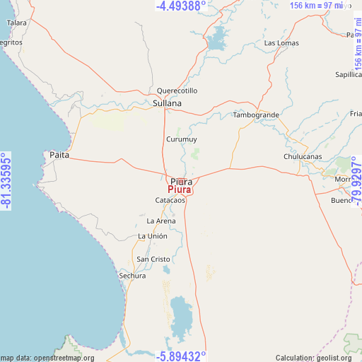
Piura GPS coordinates[2]
5° 11' 40.164" South, 80° 37' 58.152" West
| Map corner | latitude | longitude |
|---|---|---|
| Upper-left | -4.49388°, | -81.33595° |
| Center: | -5.19449°, | -80.63282° |
| Lower-right: | -5.89432°, | -79.9297° |
| Map W x H: | 155.7×155.7 km | = 96.7×96.7mi |
| max Lat: | -0.96667° ⇑5.5% North |
| Piura: | -5.19449° |
| min Lat: | ⇓94.5% South -18.01465° |
| min Long | Piura | max Long |
| -81.30472° | -80.63282° | -69.04167° |
| W 2.4%⇐ | ⇒97.6% E |
Elevation
Elevation of Piura is 33 m = 108 ft, and this is 2285.7 m = 7499 ft below average elevation for this country.
| Max E: |
5022 m = 16476 ft | 94.6% |
| Avg. | 2318.7 m = 7607 ft | |
| Piura | 33 m = 108 ft | |
Min E: |
1 m = 3 ft | 5.4% |
See also: Piura elevation on elevation.city.
Geographical zone
Piura is located in South Torrid zone (between Equator and Tropic of Capricorn). Distance of Equator is 577.6 km =358.9 mi to North.| Distance of | km | miles | from Piura |
|---|---|---|---|
| Equator | 577.6 | 358.9 | to North |
| Tropic Capricorn | 2028.3 | 1260.3 | to South |
| Antarctic Circle | 6823.6 | 4240 | to South |
| South Pole | 9429.5 | 5859.2 | to South |


Nearby cities:
15 places around Piura: (largest is in red/bold)
• Bernal
31.2 km =19.4 mi,  204°
204°
• Catacaos
9.8 km =6.1 mi,  214°
214°
• Dos Pueblos
32 km =19.9 mi, 207°
• La Arena
19 km =11.8 mi,  215°
215°
• La Unión
26.1 km =16.2 mi, 207°
• Marcavelica
36.1 km =22.4 mi,  347°
347°
• Querecotillo
39.7 km =24.7 mi,  357°
357°
• Salitral
37.9 km =23.5 mi, 351°
• San Jacinto
47.5 km =29.5 mi,  325°
325°
• Sechura
45.4 km =28.2 mi, 207°
• Sinchao
25 km =15.5 mi,  188°
188°
• Sojo
38.4 km =23.9 mi, 328°
• Sullana
32.8 km =20.4 mi, 349°
• Tambo Grande
43.6 km =27.1 mi,  47°
47°
• Vice
29.8 km =18.5 mi, 214°
Sources, notices
• [Note1] Compared only with cities in Peru existing in our database
• [Src1] Map data: © OpenStreetMap contributors (CC-BY-SA)
• [Src2] Other city data from geonames.org with taken over terms of usage.
• [Src3] Geographical zone / Annual Mean Temperature by Robert A. Rohde @ Wikipedia
