Las Lomas geodata
Las Lomas (Piura) is a seat of a third-order administrative division; located in Peru in America/Lima (GMT-5) time zone. With population of 9,450 people, there are 148 cities with bigger population in this country. Compared to other cities in Peru, 97.1% of cities are located further ↓South; 97.1% of cities are located further →East and 82.4% of cities have higher elevation than Las Lomas. Note1


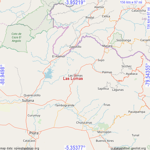
Las Lomas GPS coordinates[2]
4° 39' 11.988" South, 80° 14' 48.012" West
| Map corner | latitude | longitude |
|---|---|---|
| Upper-left | -3.95219°, | -80.9498° |
| Center: | -4.65333°, | -80.24667° |
| Lower-right: | -5.35377°, | -79.54355° |
| Map W x H: | 155.8×155.8 km | = 96.8×96.8mi |
| max Lat: | -0.96667° ⇑2.9% North |
| Las Lomas: | -4.65333° |
| min Lat: | ⇓97.1% South -18.01465° |
| min Long | Las Lomas | max Long |
| -81.30472° | -80.24667° | -69.04167° |
| W 2.9%⇐ | ⇒97.1% E |
Elevation
Elevation of Las Lomas is 242 m = 794 ft, and this is 2076.7 m = 6813 ft below average elevation for this country.
| Max E: |
5022 m = 16476 ft | 82.4% |
| Avg. | 2318.7 m = 7607 ft | |
| Las Lomas | 242 m = 794 ft | |
Min E: |
1 m = 3 ft | 17.6% |
See also: Peru elevation on elevation.city.
Geographical zone
Las Lomas is located in South Torrid zone (between Equator and Tropic of Capricorn). Distance of Equator is 517.4 km =321.5 mi to North.| Distance of | km | miles | from Las Lomas |
|---|---|---|---|
| Equator | 517.4 | 321.5 | to North |
| Tropic Capricorn | 2088.5 | 1297.7 | to South |
| Antarctic Circle | 6883.8 | 4277.4 | to South |
| South Pole | 9489.7 | 5896.6 | to South |


Nearby cities:
15 places around Las Lomas: (largest is in red/bold)
• Ayabaca
59 km =36.7 mi,  88°
88°
• Chulucanas
49.7 km =30.9 mi,  169°
169°
• Frias
45.2 km =28.1 mi,  132°
132°
• Jilili
50.4 km =31.3 mi,  81°
81°
• Lagunas
47.1 km =29.3 mi,  108°
108°
• Marcavelica
56.6 km =35.2 mi,  243°
243°
• Montero
46.4 km =28.8 mi, 86°
• Paimas
33.6 km =20.9 mi, 84°
• Querecotillo
48.7 km =30.3 mi,  245°
245°
• Salitral
53.2 km =33.1 mi, 244°
• Santo Domingo
58.5 km =36.4 mi,  135°
135°
• Sapillica
32.4 km =20.1 mi,  115°
115°
• Sullana
56 km =34.8 mi, 240°
• Suyo
31.1 km =19.3 mi,  60°
60°
• Tambo Grande
32.3 km =20.1 mi,  199°
199°
Sources, notices
• [Note1] Compared only with cities in Peru existing in our database
• [Src1] Map data: © OpenStreetMap contributors (CC-BY-SA)
• [Src2] Other city data from geonames.org with taken over terms of usage.
• [Src3] Geographical zone / Annual Mean Temperature by Robert A. Rohde @ Wikipedia
