Salitral geodata
Salitral (Piura) is a seat of a third-order administrative division; located in Peru in America/Lima (GMT-5) time zone. With population of 5,385 people, there are 227 cities with bigger population in this country. Compared to other cities in Peru, 96.4% of cities are located further ↓South; 98% of cities are located further →East and 92.7% of cities have higher elevation than Salitral. Note1


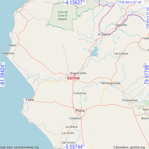
Salitral GPS coordinates[2]
4° 51' 25.992" South, 80° 40' 51.996" West
| Map corner | latitude | longitude |
|---|---|---|
| Upper-left | -4.15627°, | -81.38424° |
| Center: | -4.85722°, | -80.68111° |
| Lower-right: | -5.55744°, | -79.97799° |
| Map W x H: | 155.8×155.8 km | = 96.8×96.8mi |
| max Lat: | -0.96667° ⇑3.6% North |
| Salitral: | -4.85722° |
| min Lat: | ⇓96.4% South -18.01465° |
| min Long | Salitral | max Long |
| -81.30472° | -80.68111° | -69.04167° |
| W 2%⇐ | ⇒98% E |
Elevation
Elevation of Salitral is 52 m = 171 ft, and this is 2266.7 m = 7437 ft below average elevation for this country.
| Max E: |
5022 m = 16476 ft | 92.7% |
| Avg. | 2318.7 m = 7607 ft | |
| Salitral | 52 m = 171 ft | |
Min E: |
1 m = 3 ft | 7.3% |
See also: Peru elevation on elevation.city.
Geographical zone
Salitral is located in South Torrid zone (between Equator and Tropic of Capricorn). Distance of Equator is 540.1 km =335.6 mi to North.| Distance of | km | miles | from Salitral |
|---|---|---|---|
| Equator | 540.1 | 335.6 | to North |
| Tropic Capricorn | 2065.8 | 1283.6 | to South |
| Antarctic Circle | 6861.1 | 4263.3 | to South |
| South Pole | 9467 | 5882.5 | to South |


Nearby cities:
15 places around Salitral: (largest is in red/bold)
• Amotape
37.2 km =23.1 mi,  265°
265°
• Arenal
38.5 km =23.9 mi, 265°
• Catacaos
45.5 km =28.3 mi,  180°
180°
• La Arena
53.3 km =33.1 mi,  186°
186°
• La Huaca
31.5 km =19.6 mi,  258°
258°
• Las Lomas
53.2 km =33.1 mi,  64°
64°
• Marcavelica
3.5 km =2.2 mi,  229°
229°
• Piura
37.9 km =23.5 mi,  171°
171°
• Querecotillo
4.5 km =2.8 mi, 61°
• Salinera Colán
47 km =29.2 mi,  245°
245°
• San Jacinto
21.7 km =13.5 mi, 274°
• Sojo
15.7 km =9.8 mi, 252°
• Sullana
5.2 km =3.2 mi, 185°
• Tamarindo
32.4 km =20.1 mi, 266°
• Tambo Grande
38.1 km =23.7 mi,  101°
101°
Sources, notices
• [Note1] Compared only with cities in Peru existing in our database
• [Src1] Map data: © OpenStreetMap contributors (CC-BY-SA)
• [Src2] Other city data from geonames.org with taken over terms of usage.
• [Src3] Geographical zone / Annual Mean Temperature by Robert A. Rohde @ Wikipedia
