Lonya Grande geodata
Lonya Grande (Amazonas) is a seat of a third-order administrative division; located in Peru in America/Lima (GMT-5) time zone. In our database, there are 305 cities with bigger population. Compared to other cities in Peru, 89.3% of cities are located further ↓South; 84.7% of cities are located further →East and 71.2% of cities have higher elevation than Lonya Grande. Note1


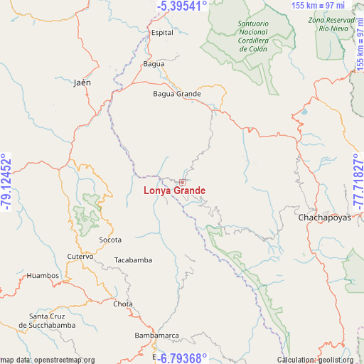
Lonya Grande GPS coordinates[2]
6° 5' 42" South, 78° 25' 17.004" West
| Map corner | latitude | longitude |
|---|---|---|
| Upper-left | -5.39541°, | -79.12452° |
| Center: | -6.095°, | -78.42139° |
| Lower-right: | -6.79368°, | -77.71827° |
| Map W x H: | 155.5×155.5 km | = 96.6×96.6mi |
| max Lat: | -0.96667° ⇑10.7% North |
| Lonya Grande: | -6.095° |
| min Lat: | ⇓89.3% South -18.01465° |
| min Long | Lonya Grande | max Long |
| -81.30472° | -78.42139° | -69.04167° |
| W 15.3%⇐ | ⇒84.7% E |
Elevation
Elevation of Lonya Grande is 1209 m = 3967 ft, and this is 1109.7 m = 3641 ft below average elevation for this country.
| Max E: |
5022 m = 16476 ft | 71.2% |
| Avg. | 2318.7 m = 7607 ft | |
| Lonya Grande | 1209 m = 3967 ft | |
Min E: |
1 m = 3 ft | 28.8% |
See also: Peru elevation on elevation.city.
Geographical zone
Lonya Grande is located in South Torrid zone (between Equator and Tropic of Capricorn). Distance of Equator is 677.7 km =421.1 mi to North.| Distance of | km | miles | from Lonya Grande |
|---|---|---|---|
| Equator | 677.7 | 421.1 | to North |
| Tropic Capricorn | 1928.2 | 1198.1 | to South |
| Antarctic Circle | 6723.5 | 4177.8 | to South |
| South Pole | 9329.4 | 5797 | to South |


Nearby cities:
15 places around Lonya Grande: (largest is in red/bold)
• Bagua Grande
37.7 km =23.4 mi,  356°
356°
• Cajaruro
39.9 km =24.8 mi, 359°
• Chalamarca
44.4 km =27.6 mi,  186°
186°
• Choropampa
38.9 km =24.2 mi,  168°
168°
• Choros
37.1 km =23.1 mi,  305°
305°
• Collonce
31 km =19.3 mi,  131°
131°
• Cujillo
12.6 km =7.8 mi,  258°
258°
• Cumba
32.2 km =20 mi,  304°
304°
• Jamalca
30.9 km =19.2 mi,  34°
34°
• La Sacilia
37.4 km =23.2 mi, 295°
• Paccha
44.8 km =27.8 mi,  179°
179°
• Providencia
30.1 km =18.7 mi,  138°
138°
• Santa Catalina
39.8 km =24.7 mi,  92°
92°
• Socota
41.3 km =25.7 mi,  236°
236°
• Tacabamba
38.6 km =24 mi,  213°
213°
Sources, notices
• [Note1] Compared only with cities in Peru existing in our database
• [Src1] Map data: © OpenStreetMap contributors (CC-BY-SA)
• [Src2] Other city data from geonames.org with taken over terms of usage.
• [Src3] Geographical zone / Annual Mean Temperature by Robert A. Rohde @ Wikipedia
