Sorochuco geodata
Sorochuco (Cajamarca) is a seat of a third-order administrative division; located in Peru in America/Lima (GMT-5) time zone. In our database, there are 305 cities with bigger population. Compared to other cities in Peru, 80.6% of cities are located further ↓South; 83.7% of cities are located further →East and 55.8% of cities have higher elevation than Sorochuco. Note1


Sorochuco GPS coordinates[2]
6° 54' 38.988" South, 78° 15' 18" West
| Map corner | latitude | longitude |
|---|---|---|
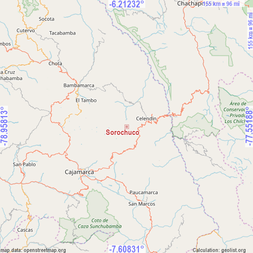
| Upper-left | -6.21232°, | -78.95813° |
| Center: | -6.91083°, | -78.255° |
| Lower-right: | -7.60831°, | -77.55188° |
| Map W x H: | 155.2×155.2 km | = 96.4×96.4mi |
| max Lat: | -0.96667° ⇑19.4% North |
| Sorochuco: | -6.91083° |
| min Lat: | ⇓80.6% South -18.01465° |
| min Long | Sorochuco | max Long |
| -81.30472° | -78.255° | -69.04167° |
| W 16.3%⇐ | ⇒83.7% E |
Elevation
Elevation of Sorochuco is 2657 m = 8717 ft, and this is 338.3 m = 1110 ft above average elevation for this country.
| Max E: |
5022 m = 16476 ft | 55.8% |
| Sorochuco | 2657 m 8717 ft | |
| Avg. | 2318.7 m = 7607 ft | |
Min E: |
1 m = 3 ft | 44.2% |
See also: Peru elevation on elevation.city.
Geographical zone
Sorochuco is located in South Torrid zone (between Equator and Tropic of Capricorn). Distance of Equator is 768.4 km =477.5 mi to North.| Distance of | km | miles | from Sorochuco |
|---|---|---|---|
| Equator | 768.4 | 477.5 | to North |
| Tropic Capricorn | 1837.5 | 1141.8 | to South |
| Antarctic Circle | 6632.8 | 4121.4 | to South |
| South Pole | 9238.6 | 5740.6 | to South |


Nearby cities:
15 places around Sorochuco: (largest is in red/bold)
• Balsas
27.7 km =17.2 mi,  71°
71°
• Bambamarca
39.8 km =24.7 mi,  309°
309°
• Cajamarca
39 km =24.2 mi,  223°
223°
• Celendín
13 km =8.1 mi, 67°
• Chumuch
34.8 km =21.6 mi,  6°
6°
• Encañada
21.9 km =13.6 mi,  208°
208°
• Huacapampa
13.7 km =8.5 mi,  100°
100°
• Hualgayoc
43 km =26.7 mi,  291°
291°
• Llacanora
37.7 km =23.4 mi, 211°
• Longotea
41.2 km =25.6 mi,  114°
114°
• Lucmapampa
17.7 km =11 mi, 104°
• Namora
33.3 km =20.7 mi,  195°
195°
• Oxamarca
24.9 km =15.5 mi,  123°
123°
• Sucre
11.9 km =7.4 mi, 102°
• Utco
22.6 km =14 mi,  91°
91°
Sources, notices
• [Note1] Compared only with cities in Peru existing in our database
• [Src1] Map data: © OpenStreetMap contributors (CC-BY-SA)
• [Src2] Other city data from geonames.org with taken over terms of usage.
• [Src3] Geographical zone / Annual Mean Temperature by Robert A. Rohde @ Wikipedia
