Longotea geodata
Longotea (La Libertad) is a seat of a third-order administrative division; located in Peru in America/Lima (GMT-5) time zone. In our database, there are 305 cities with bigger population. Compared to other cities in Peru, 78.9% of cities are located further ↓South; 79.9% of cities are located further →East and 54.3% of cities have higher elevation than Longotea. Note1


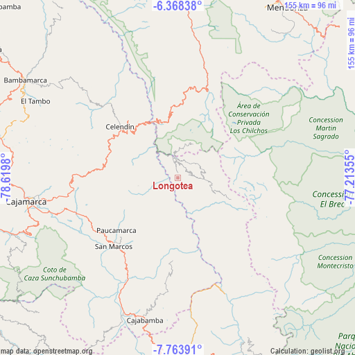
Longotea GPS coordinates[2]
7° 4' 0.012" South, 77° 55' 0.012" West
| Map corner | latitude | longitude |
|---|---|---|
| Upper-left | -6.36838°, | -78.6198° |
| Center: | -7.06667°, | -77.91667° |
| Lower-right: | -7.76391°, | -77.21355° |
| Map W x H: | 155.2×155.2 km | = 96.4×96.4mi |
| max Lat: | -0.96667° ⇑21.1% North |
| Longotea: | -7.06667° |
| min Lat: | ⇓78.9% South -18.01465° |
| min Long | Longotea | max Long |
| -81.30472° | -77.91667° | -69.04167° |
| W 20.1%⇐ | ⇒79.9% E |
Elevation
Elevation of Longotea is 2708 m = 8885 ft, and this is 389.3 m = 1277 ft above average elevation for this country.
| Max E: |
5022 m = 16476 ft | 54.3% |
| Longotea | 2708 m 8885 ft | |
| Avg. | 2318.7 m = 7607 ft | |
Min E: |
1 m = 3 ft | 45.7% |
See also: Peru elevation on elevation.city.
Geographical zone
Longotea is located in South Torrid zone (between Equator and Tropic of Capricorn). Distance of Equator is 785.7 km =488.2 mi to North.| Distance of | km | miles | from Longotea |
|---|---|---|---|
| Equator | 785.7 | 488.2 | to North |
| Tropic Capricorn | 1820.2 | 1131 | to South |
| Antarctic Circle | 6615.4 | 4110.6 | to South |
| South Pole | 9221.3 | 5729.8 | to South |


Nearby cities:
15 places around Longotea: (largest is in red/bold)
• Balsas
28.2 km =17.5 mi,  336°
336°
• Bolívar
25.5 km =15.8 mi,  112°
112°
• Celendín
33.7 km =20.9 mi,  311°
311°
• Chuquibamba
16.4 km =10.2 mi,  25°
25°
• Encañada
47.9 km =29.8 mi,  267°
267°
• Huacapampa
28.1 km =17.5 mi,  301°
301°
• Lucmapampa
24 km =14.9 mi, 302°
• Namora
48.3 km =30 mi,  252°
252°
• Oxamarca
17 km =10.6 mi,  282°
282°
• San Marcos
41.8 km =26 mi,  224°
224°
• Shirac
34.8 km =21.6 mi,  205°
205°
• Sorochuco
41.2 km =25.6 mi,  294°
294°
• Sucre
29.7 km =18.5 mi, 299°
• Ucuncha
8.3 km =5.2 mi,  153°
153°
• Utco
22.2 km =13.8 mi,  318°
318°
Sources, notices
• [Note1] Compared only with cities in Peru existing in our database
• [Src1] Map data: © OpenStreetMap contributors (CC-BY-SA)
• [Src2] Other city data from geonames.org with taken over terms of usage.
• [Src3] Geographical zone / Annual Mean Temperature by Robert A. Rohde @ Wikipedia
