Cajamarca geodata
Cajamarca is a seat of a first-order administrative division; located in Peru in America/Lima (GMT-5) time zone. With population of 135,000 people, there are 19 cities with bigger population in this country. Compared to other cities in Peru, 78.2% of cities are located further ↓South; 85.8% of cities are located further →East and 55% of cities have higher elevation than Cajamarca. Note1


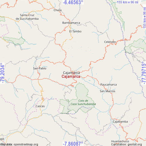
Cajamarca GPS coordinates[2]
7° 9' 49.608" South, 78° 30' 0.972" West
| Map corner | latitude | longitude |
|---|---|---|
| Upper-left | -6.46563°, | -79.2034° |
| Center: | -7.16378°, | -78.50027° |
| Lower-right: | -7.86087°, | -77.79715° |
| Map W x H: | 155.1×155.1 km | = 96.4×96.4mi |
| max Lat: | -0.96667° ⇑21.8% North |
| Cajamarca: | -7.16378° |
| min Lat: | ⇓78.2% South -18.01465° |
| min Long | Cajamarca | max Long |
| -81.30472° | -78.50027° | -69.04167° |
| W 14.2%⇐ | ⇒85.8% E |
Elevation
Elevation of Cajamarca is 2684 m = 8806 ft, and this is 365.3 m = 1198 ft above average elevation for this country.
| Max E: |
5022 m = 16476 ft | 55% |
| Cajamarca | 2684 m 8806 ft | |
| Avg. | 2318.7 m = 7607 ft | |
Min E: |
1 m = 3 ft | 45% |
See also: Cajamarca elevation on elevation.city.
Geographical zone
Cajamarca is located in South Torrid zone (between Equator and Tropic of Capricorn). Distance of Equator is 796.5 km =494.9 mi to North.| Distance of | km | miles | from Cajamarca |
|---|---|---|---|
| Equator | 796.5 | 494.9 | to North |
| Tropic Capricorn | 1809.4 | 1124.3 | to South |
| Antarctic Circle | 6604.6 | 4103.9 | to South |
| South Pole | 9210.5 | 5723.1 | to South |


Nearby cities:
15 places around Cajamarca: (largest is in red/bold)
• Cachachi
39.8 km =24.7 mi,  143°
143°
• Chetilla
18.4 km =11.4 mi,  274°
274°
• Chilete
39.3 km =24.4 mi,  258°
258°
• Encañada
18.8 km =11.7 mi,  61°
61°
• Hualgayoc
46 km =28.6 mi,  343°
343°
• Llacanora
8.4 km =5.2 mi,  118°
118°
• Llapa
40.3 km =25 mi,  299°
299°
• Magdalena
20.7 km =12.9 mi,  242°
242°
• Namora
18.9 km =11.7 mi,  102°
102°
• San Bernardino
36.8 km =22.9 mi, 266°
• San Juan
15.1 km =9.4 mi,  179°
179°
• San Marcos
39.7 km =24.7 mi, 118°
• San Pablo
37.1 km =23.1 mi,  278°
278°
• Sorochuco
39 km =24.2 mi,  43°
43°
• Sucre
46.4 km =28.8 mi, 56°
Sources, notices
• [Note1] Compared only with cities in Peru existing in our database
• [Src1] Map data: © OpenStreetMap contributors (CC-BY-SA)
• [Src2] Other city data from geonames.org with taken over terms of usage.
• [Src3] Geographical zone / Annual Mean Temperature by Robert A. Rohde @ Wikipedia
