Utco geodata
Utco (Cajamarca) is a seat of a third-order administrative division; located in Peru in America/Lima (GMT-5) time zone. In our database, there are 305 cities with bigger population. Compared to other cities in Peru, 80.5% of cities are located further ↓South; 82% of cities are located further →East and 68.7% of cities have higher elevation than Utco. Note1


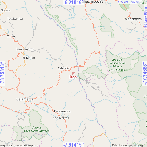
Utco GPS coordinates[2]
6° 55' 0.012" South, 78° 3' 0" West
| Map corner | latitude | longitude |
|---|---|---|
| Upper-left | -6.21816°, | -78.75313° |
| Center: | -6.91667°, | -78.05° |
| Lower-right: | -7.61415°, | -77.34688° |
| Map W x H: | 155.2×155.2 km | = 96.4×96.4mi |
| max Lat: | -0.96667° ⇑19.5% North |
| Utco: | -6.91667° |
| min Lat: | ⇓80.5% South -18.01465° |
| min Long | Utco | max Long |
| -81.30472° | -78.05° | -69.04167° |
| W 18%⇐ | ⇒82% E |
Elevation
Elevation of Utco is 1622 m = 5322 ft, and this is 696.7 m = 2286 ft below average elevation for this country.
| Max E: |
5022 m = 16476 ft | 68.7% |
| Avg. | 2318.7 m = 7607 ft | |
| Utco | 1622 m = 5322 ft | |
Min E: |
1 m = 3 ft | 31.3% |
See also: Peru elevation on elevation.city.
Geographical zone
Utco is located in South Torrid zone (between Equator and Tropic of Capricorn). Distance of Equator is 769.1 km =477.9 mi to North.| Distance of | km | miles | from Utco |
|---|---|---|---|
| Equator | 769.1 | 477.9 | to North |
| Tropic Capricorn | 1836.9 | 1141.4 | to South |
| Antarctic Circle | 6632.1 | 4121 | to South |
| South Pole | 9238 | 5740.2 | to South |


Nearby cities:
15 places around Utco: (largest is in red/bold)
• Balsas
10 km =6.2 mi,  21°
21°
• Celendín
12 km =7.5 mi,  298°
298°
• Chumuch
39.7 km =24.7 mi,  332°
332°
• Chuquibamba
21.9 km =13.6 mi,  95°
95°
• Cocabamba
35.4 km =22 mi,  5°
5°
• Encañada
37.9 km =23.5 mi,  240°
240°
• Huacapampa
9.4 km =5.8 mi,  258°
258°
• Longotea
22.2 km =13.8 mi,  138°
138°
• Lucmapampa
6.6 km =4.1 mi, 236°
• Montevideo
43.2 km =26.8 mi,  39°
39°
• Namora
44.4 km =27.6 mi,  224°
224°
• Oxamarca
13.1 km =8.1 mi,  188°
188°
• Sorochuco
22.6 km =14 mi,  271°
271°
• Sucre
11.2 km =7 mi, 260°
• Ucuncha
30.3 km =18.8 mi, 142°
Sources, notices
• [Note1] Compared only with cities in Peru existing in our database
• [Src1] Map data: © OpenStreetMap contributors (CC-BY-SA)
• [Src2] Other city data from geonames.org with taken over terms of usage.
• [Src3] Geographical zone / Annual Mean Temperature by Robert A. Rohde @ Wikipedia
