Simbal geodata
Simbal (La Libertad) is a seat of a third-order administrative division; located in Peru in America/Lima (GMT-5) time zone. In our database, there are 305 cities with bigger population. Compared to other cities in Peru, 74.2% of cities are located further ↓South; 88.5% of cities are located further →East and 76.9% of cities have higher elevation than Simbal. Note1


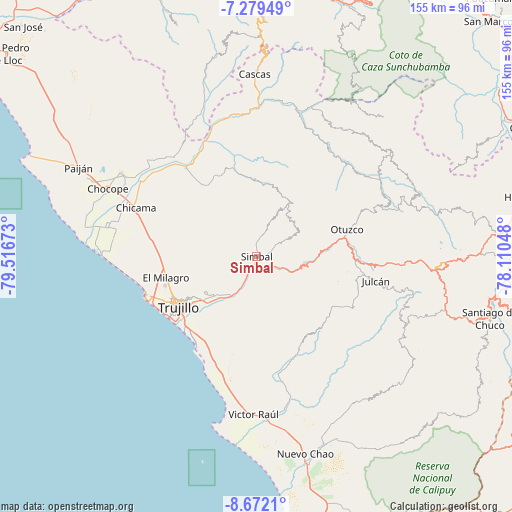
Simbal GPS coordinates[2]
7° 58' 35.004" South, 78° 48' 48.96" West
| Map corner | latitude | longitude |
|---|---|---|
| Upper-left | -7.27949°, | -79.51673° |
| Center: | -7.97639°, | -78.8136° |
| Lower-right: | -8.6721°, | -78.11048° |
| Map W x H: | 154.8×154.8 km | = 96.2×96.2mi |
| max Lat: | -0.96667° ⇑25.8% North |
| Simbal: | -7.97639° |
| min Lat: | ⇓74.2% South -18.01465° |
| min Long | Simbal | max Long |
| -81.30472° | -78.8136° | -69.04167° |
| W 11.5%⇐ | ⇒88.5% E |
Elevation
Elevation of Simbal is 589 m = 1932 ft, and this is 1729.7 m = 5675 ft below average elevation for this country.
| Max E: |
5022 m = 16476 ft | 76.9% |
| Avg. | 2318.7 m = 7607 ft | |
| Simbal | 589 m = 1932 ft | |
Min E: |
1 m = 3 ft | 23.1% |
See also: Peru elevation on elevation.city.
Geographical zone
Simbal is located in South Torrid zone (between Equator and Tropic of Capricorn). Distance of Equator is 886.9 km =551.1 mi to North.| Distance of | km | miles | from Simbal |
|---|---|---|---|
| Equator | 886.9 | 551.1 | to North |
| Tropic Capricorn | 1719 | 1068.1 | to South |
| Antarctic Circle | 6514.3 | 4047.8 | to South |
| South Pole | 9120.2 | 5667 | to South |


Nearby cities:
15 places around Simbal: (largest is in red/bold)
• Agallpampa
29 km =18 mi,  91°
91°
• Buenos Aires
30.8 km =19.1 mi,  234°
234°
• Carabamba
26.7 km =16.6 mi,  125°
125°
• El Porvenir
23.7 km =14.7 mi,  239°
239°
• La Cuesta
12.6 km =7.8 mi,  58°
58°
• La Esperanza
27.7 km =17.2 mi,  246°
246°
• Laredo
20.5 km =12.7 mi, 232°
• Mache
31.5 km =19.6 mi,  101°
101°
• Moche
30.5 km =19 mi,  224°
224°
• Otuzco
26.7 km =16.6 mi,  71°
71°
• Poroto
6.4 km =4 mi, 127°
• Salaverry
32.6 km =20.3 mi,  213°
213°
• Salpo
21.8 km =13.5 mi, 96°
• Sinsicap
16.7 km =10.4 mi,  18°
18°
• Trujillo
28.4 km =17.6 mi, 236°
Sources, notices
• [Note1] Compared only with cities in Peru existing in our database
• [Src1] Map data: © OpenStreetMap contributors (CC-BY-SA)
• [Src2] Other city data from geonames.org with taken over terms of usage.
• [Src3] Geographical zone / Annual Mean Temperature by Robert A. Rohde @ Wikipedia
