Moche geodata
Moche (La Libertad) is a seat of a third-order administrative division; located in Peru in America/Lima (GMT-5) time zone. With population of 22,581 people, there are 78 cities with bigger population in this country. Compared to other cities in Peru, 72.9% of cities are located further ↓South; 90% of cities are located further →East and 98.1% of cities have higher elevation than Moche. Note1


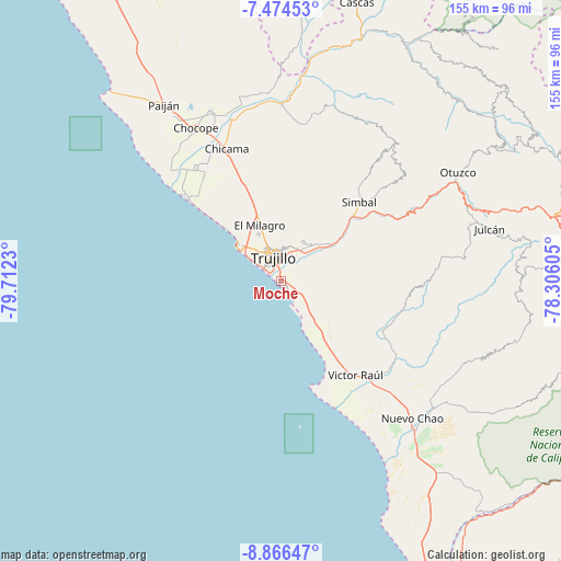
Moche GPS coordinates[2]
8° 10' 15.996" South, 79° 0' 33.012" West
| Map corner | latitude | longitude |
|---|---|---|
| Upper-left | -7.47453°, | -79.7123° |
| Center: | -8.17111°, | -79.00917° |
| Lower-right: | -8.86647°, | -78.30605° |
| Map W x H: | 154.8×154.8 km | = 96.2×96.2mi |
| max Lat: | -0.96667° ⇑27.1% North |
| Moche: | -8.17111° |
| min Lat: | ⇓72.9% South -18.01465° |
| min Long | Moche | max Long |
| -81.30472° | -79.00917° | -69.04167° |
| W 10%⇐ | ⇒90% E |
Elevation
Elevation of Moche is 13 m = 43 ft, and this is 2305.7 m = 7565 ft below average elevation for this country.
| Max E: |
5022 m = 16476 ft | 98.1% |
| Avg. | 2318.7 m = 7607 ft | |
| Moche | 13 m = 43 ft | |
Min E: |
1 m = 3 ft | 1.9% |
See also: Peru elevation on elevation.city.
Geographical zone
Moche is located in South Torrid zone (between Equator and Tropic of Capricorn). Distance of Equator is 908.5 km =564.5 mi to North.| Distance of | km | miles | from Moche |
|---|---|---|---|
| Equator | 908.5 | 564.5 | to North |
| Tropic Capricorn | 1697.4 | 1054.7 | to South |
| Antarctic Circle | 6492.6 | 4034.3 | to South |
| South Pole | 9098.5 | 5653.5 | to South |


Nearby cities:
15 places around Moche: (largest is in red/bold)
• Buenos Aires
5 km =3.1 mi,  316°
316°
• Carabamba
43.6 km =27.1 mi,  82°
82°
• Chicama
39.3 km =24.4 mi,  337°
337°
• El Porvenir
9.8 km =6.1 mi,  5°
5°
• Huanchaco
15.3 km =9.5 mi,  309°
309°
• La Cuesta
42.9 km =26.7 mi,  48°
48°
• La Esperanza
11.2 km =7 mi, 340°
• Laredo
10.5 km =6.5 mi,  30°
30°
• Poroto
32 km =19.9 mi,  56°
56°
• Salaverry
6.6 km =4.1 mi,  147°
147°
• Santiago de Cao
34.6 km =21.5 mi, 312°
• Simbal
30.5 km =19 mi,  44°
44°
• Sinsicap
46.1 km =28.6 mi, 35°
• Trujillo
6.5 km =4 mi, 339°
• Virú
39.2 km =24.4 mi,  133°
133°
Sources, notices
• [Note1] Compared only with cities in Peru existing in our database
• [Src1] Map data: © OpenStreetMap contributors (CC-BY-SA)
• [Src2] Other city data from geonames.org with taken over terms of usage.
• [Src3] Geographical zone / Annual Mean Temperature by Robert A. Rohde @ Wikipedia
