Salaverry geodata
Salaverry (La Libertad) is a seat of a third-order administrative division; located in Peru in America/Lima (GMT-5) time zone. With population of 10,066 people, there are 142 cities with bigger population in this country. Compared to other cities in Peru, 72.5% of cities are located further ↓South; 89.7% of cities are located further →East and 99.2% of cities have higher elevation than Salaverry. Note1


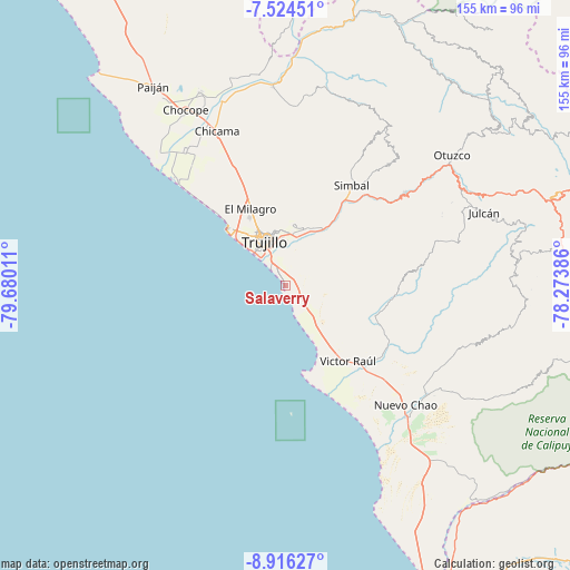
Salaverry GPS coordinates[2]
8° 13' 15.6" South, 78° 58' 37.128" West
| Map corner | latitude | longitude |
|---|---|---|
| Upper-left | -7.52451°, | -79.68011° |
| Center: | -8.221°, | -78.97698° |
| Lower-right: | -8.91627°, | -78.27386° |
| Map W x H: | 154.7×154.8 km | = 96.1×96.2mi |
| max Lat: | -0.96667° ⇑27.5% North |
| Salaverry: | -8.221° |
| min Lat: | ⇓72.5% South -18.01465° |
| min Long | Salaverry | max Long |
| -81.30472° | -78.97698° | -69.04167° |
| W 10.3%⇐ | ⇒89.7% E |
Elevation
Elevation of Salaverry is 8 m = 26 ft, and this is 2310.7 m = 7581 ft below average elevation for this country.
| Max E: |
5022 m = 16476 ft | 99.2% |
| Avg. | 2318.7 m = 7607 ft | |
| Salaverry | 8 m = 26 ft | |
Min E: |
1 m = 3 ft | 0.8% |
See also: Peru elevation on elevation.city.
Geographical zone
Salaverry is located in South Torrid zone (between Equator and Tropic of Capricorn). Distance of Equator is 914.1 km =568 mi to North.| Distance of | km | miles | from Salaverry |
|---|---|---|---|
| Equator | 914.1 | 568 | to North |
| Tropic Capricorn | 1691.8 | 1051.2 | to South |
| Antarctic Circle | 6487.1 | 4030.9 | to South |
| South Pole | 9093 | 5650.1 | to South |


Nearby cities:
15 places around Salaverry: (largest is in red/bold)
• Buenos Aires
11.5 km =7.1 mi,  322°
322°
• Carabamba
41.3 km =25.7 mi,  73°
73°
• Chicama
45.8 km =28.5 mi,  335°
335°
• El Porvenir
15.5 km =9.6 mi,  350°
350°
• Huanchaco
21.7 km =13.5 mi,  314°
314°
• La Cuesta
44.3 km =27.5 mi,  40°
40°
• La Esperanza
17.7 km =11 mi, 335°
• Laredo
14.7 km =9.1 mi,  7°
7°
• Moche
6.6 km =4.1 mi,  327°
327°
• Poroto
32.8 km =20.4 mi, 44°
• Salpo
46.7 km =29 mi,  58°
58°
• Santiago de Cao
41 km =25.5 mi, 315°
• Simbal
32.6 km =20.3 mi,  33°
33°
• Trujillo
13.1 km =8.1 mi, 333°
• Virú
32.9 km =20.4 mi,  131°
131°
Sources, notices
• [Note1] Compared only with cities in Peru existing in our database
• [Src1] Map data: © OpenStreetMap contributors (CC-BY-SA)
• [Src2] Other city data from geonames.org with taken over terms of usage.
• [Src3] Geographical zone / Annual Mean Temperature by Robert A. Rohde @ Wikipedia
