Otuzco geodata
Otuzco (La Libertad) is a seat of a third-order administrative division; located in Peru in America/Lima (GMT-5) time zone. With population of 10,134 people, there are 141 cities with bigger population in this country. Compared to other cities in Peru, 74.5% of cities are located further ↓South; 86.4% of cities are located further →East and 54.3% of cities have lower elevation than Otuzco. Note1


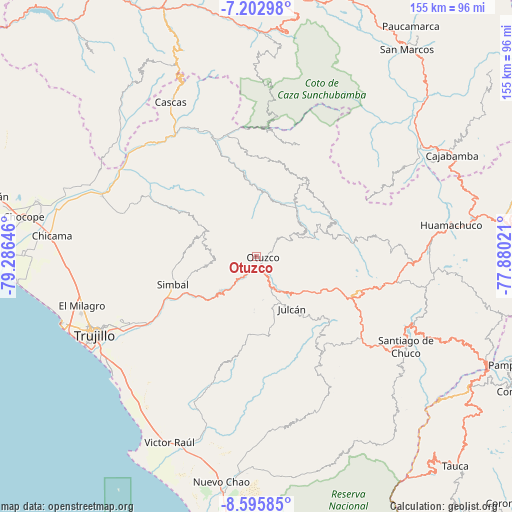
Otuzco GPS coordinates[2]
7° 54' 0" South, 78° 34' 59.988" West
| Map corner | latitude | longitude |
|---|---|---|
| Upper-left | -7.20298°, | -79.28646° |
| Center: | -7.9°, | -78.58333° |
| Lower-right: | -8.59585°, | -77.88021° |
| Map W x H: | 154.9×154.9 km | = 96.3×96.3mi |
| max Lat: | -0.96667° ⇑25.5% North |
| Otuzco: | -7.9° |
| min Lat: | ⇓74.5% South -18.01465° |
| min Long | Otuzco | max Long |
| -81.30472° | -78.58333° | -69.04167° |
| W 13.6%⇐ | ⇒86.4% E |
Elevation
Elevation of Otuzco is 3006 m = 9862 ft, and this is 687.3 m = 2255 ft above average elevation for this country.
| Max E: |
5022 m = 16476 ft | 45.7% |
| Otuzco | 3006 m 9862 ft | |
| Avg. | 2318.7 m = 7607 ft | |
Min E: |
1 m = 3 ft | 54.3% |
See also: Peru elevation on elevation.city.
Geographical zone
Otuzco is located in South Torrid zone (between Equator and Tropic of Capricorn). Distance of Equator is 878.4 km =545.8 mi to North.| Distance of | km | miles | from Otuzco |
|---|---|---|---|
| Equator | 878.4 | 545.8 | to North |
| Tropic Capricorn | 1727.5 | 1073.4 | to South |
| Antarctic Circle | 6522.8 | 4053.1 | to South |
| South Pole | 9128.7 | 5672.3 | to South |


Nearby cities:
15 places around Otuzco: (largest is in red/bold)
• Agallpampa
10 km =6.2 mi,  158°
158°
• Carabamba
24.4 km =15.2 mi,  188°
188°
• Charat
16.5 km =10.3 mi,  63°
63°
• Huaranchal
28.2 km =17.5 mi,  31°
31°
• La Cuesta
14.8 km =9.2 mi,  262°
262°
• Laredo
46.5 km =28.9 mi,  243°
243°
• Lucma
29.9 km =18.6 mi,  7°
7°
• Mache
15.8 km =9.8 mi, 159°
• Poroto
23.8 km =14.8 mi, 238°
• Quiruvilca
42.9 km =26.7 mi,  99°
99°
• Salpo
11.7 km =7.3 mi,  198°
198°
• Sayapullo
35.7 km =22.2 mi,  21°
21°
• Simbal
26.7 km =16.6 mi,  251°
251°
• Sinsicap
21.5 km =13.4 mi,  290°
290°
• Usquil
20.6 km =12.8 mi, 63°
Sources, notices
• [Note1] Compared only with cities in Peru existing in our database
• [Src1] Map data: © OpenStreetMap contributors (CC-BY-SA)
• [Src2] Other city data from geonames.org with taken over terms of usage.
• [Src3] Geographical zone / Annual Mean Temperature by Robert A. Rohde @ Wikipedia
