Olleros geodata
Olleros (Ancash) is a seat of a third-order administrative division; located in Peru in America/Lima (GMT-5) time zone. In our database, there are 305 cities with bigger population. Compared to other cities in Peru, 63.7% of cities are located further ↓South; 72.8% of cities are located further →East and 80% of cities have lower elevation than Olleros. Note1


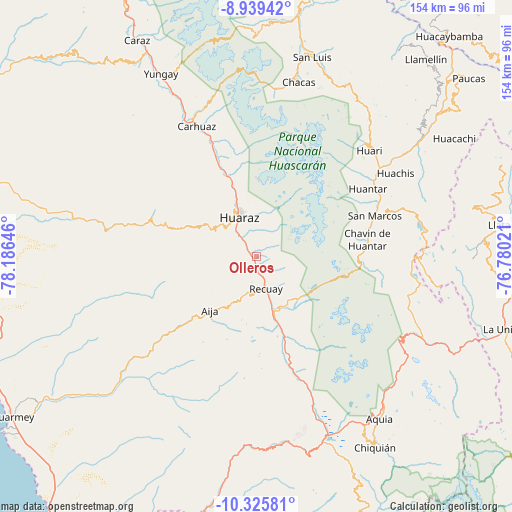
Olleros GPS coordinates[2]
9° 37' 59.988" South, 77° 28' 59.988" West
| Map corner | latitude | longitude |
|---|---|---|
| Upper-left | -8.93942°, | -78.18646° |
| Center: | -9.63333°, | -77.48333° |
| Lower-right: | -10.32581°, | -76.78021° |
| Map W x H: | 154.2×154.2 km | = 95.8×95.8mi |
| max Lat: | -0.96667° ⇑36.3% North |
| Olleros: | -9.63333° |
| min Lat: | ⇓63.7% South -18.01465° |
| min Long | Olleros | max Long |
| -81.30472° | -77.48333° | -69.04167° |
| W 27.2%⇐ | ⇒72.8% E |
Elevation
Elevation of Olleros is 3522 m = 11555 ft, and this is 1203.3 m = 3948 ft above average elevation for this country.
| Max E: |
5022 m = 16476 ft | 20% |
| Olleros | 3522 m 11555 ft | |
| Avg. | 2318.7 m = 7607 ft | |
Min E: |
1 m = 3 ft | 80% |
See also: Peru elevation on elevation.city.
Geographical zone
Olleros is located in South Torrid zone (between Equator and Tropic of Capricorn). Distance of Equator is 1071.1 km =665.6 mi to North.| Distance of | km | miles | from Olleros |
|---|---|---|---|
| Equator | 1071.1 | 665.6 | to North |
| Tropic Capricorn | 1534.8 | 953.7 | to South |
| Antarctic Circle | 6330 | 3933.3 | to South |
| South Pole | 8935.9 | 5552.5 | to South |


Nearby cities:
15 places around Olleros: (largest is in red/bold)
• Aco
30.7 km =19.1 mi,  343°
343°
• Aija
21.5 km =13.4 mi,  220°
220°
• Anta
33 km =20.5 mi, 337°
• Cajamarquilla
29.2 km =18.1 mi,  270°
270°
• Catac
19.3 km =12 mi,  163°
163°
• Coris
36.7 km =22.8 mi,  232°
232°
• Huaraz
12.7 km =7.9 mi, 337°
• Jangas
27.6 km =17.1 mi, 338°
• La Merced
18.5 km =11.5 mi, 232°
• Pira
26.6 km =16.5 mi,  286°
286°
• Recuay
10.3 km =6.4 mi, 163°
• Succha
28.8 km =17.9 mi, 219°
• Tarica
28.5 km =17.7 mi, 339°
• Ticapampa
13.5 km =8.4 mi, 164°
• Yungar
30.9 km =19.2 mi, 337°
Sources, notices
• [Note1] Compared only with cities in Peru existing in our database
• [Src1] Map data: © OpenStreetMap contributors (CC-BY-SA)
• [Src2] Other city data from geonames.org with taken over terms of usage.
• [Src3] Geographical zone / Annual Mean Temperature by Robert A. Rohde @ Wikipedia
