Huaraz geodata
Huaraz (Ancash) is a seat of a first-order administrative division; located in Peru in America/Lima (GMT-5) time zone. With population of 86,934 people, there are 24 cities with bigger population in this country. Compared to other cities in Peru, 64.3% of cities are located further ↓South; 73.1% of cities are located further →East and 56.4% of cities have lower elevation than Huaraz. Note1


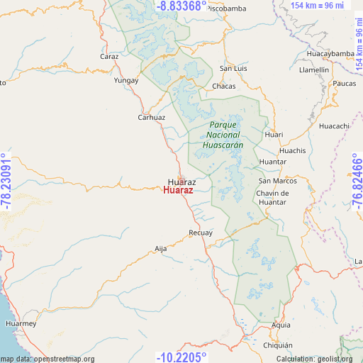
Huaraz GPS coordinates[2]
9° 31' 40.044" South, 77° 31' 40.008" West
| Map corner | latitude | longitude |
|---|---|---|
| Upper-left | -8.83368°, | -78.23091° |
| Center: | -9.52779°, | -77.52778° |
| Lower-right: | -10.2205°, | -76.82466° |
| Map W x H: | 154.2×154.2 km | = 95.8×95.8mi |
| max Lat: | -0.96667° ⇑35.7% North |
| Huaraz: | -9.52779° |
| min Lat: | ⇓64.3% South -18.01465° |
| min Long | Huaraz | max Long |
| -81.30472° | -77.52778° | -69.04167° |
| W 26.9%⇐ | ⇒73.1% E |
Elevation
Elevation of Huaraz is 3059 m = 10036 ft, and this is 740.3 m = 2429 ft above average elevation for this country.
| Max E: |
5022 m = 16476 ft | 43.6% |
| Huaraz | 3059 m 10036 ft | |
| Avg. | 2318.7 m = 7607 ft | |
Min E: |
1 m = 3 ft | 56.4% |
See also: Huaraz elevation on elevation.city.
Geographical zone
Huaraz is located in South Torrid zone (between Equator and Tropic of Capricorn). Distance of Equator is 1059.4 km =658.3 mi to North.| Distance of | km | miles | from Huaraz |
|---|---|---|---|
| Equator | 1059.4 | 658.3 | to North |
| Tropic Capricorn | 1546.5 | 961 | to South |
| Antarctic Circle | 6341.8 | 3940.6 | to South |
| South Pole | 8947.7 | 5559.8 | to South |


Nearby cities:
15 places around Huaraz: (largest is in red/bold)
• Aco
18.1 km =11.2 mi,  347°
347°
• Acopampa
27.5 km =17.1 mi,  338°
338°
• Aija
29.5 km =18.3 mi,  197°
197°
• Anta
20.3 km =12.6 mi, 337°
• Cajamarquilla
27 km =16.8 mi,  244°
244°
• Carhuaz
30.2 km =18.8 mi,  334°
334°
• Jangas
14.9 km =9.3 mi, 339°
• La Merced
25 km =15.5 mi, 202°
• Marcara District
24.3 km =15.1 mi, 339°
• Olleros
12.7 km =7.9 mi,  157°
157°
• Pira
21.2 km =13.2 mi,  258°
258°
• Recuay
23 km =14.3 mi, 160°
• Tarica
15.8 km =9.8 mi, 340°
• Ticapampa
26.1 km =16.2 mi, 160°
• Yungar
18.2 km =11.3 mi, 336°
Sources, notices
• [Note1] Compared only with cities in Peru existing in our database
• [Src1] Map data: © OpenStreetMap contributors (CC-BY-SA)
• [Src2] Other city data from geonames.org with taken over terms of usage.
• [Src3] Geographical zone / Annual Mean Temperature by Robert A. Rohde @ Wikipedia
