Aija geodata
Aija (Ancash) is a seat of a third-order administrative division; located in Peru in America/Lima (GMT-5) time zone. In our database, there are 305 cities with bigger population. Compared to other cities in Peru, 62.8% of cities are located further ↓South; 74.5% of cities are located further →East and 73.9% of cities have lower elevation than Aija. Note1


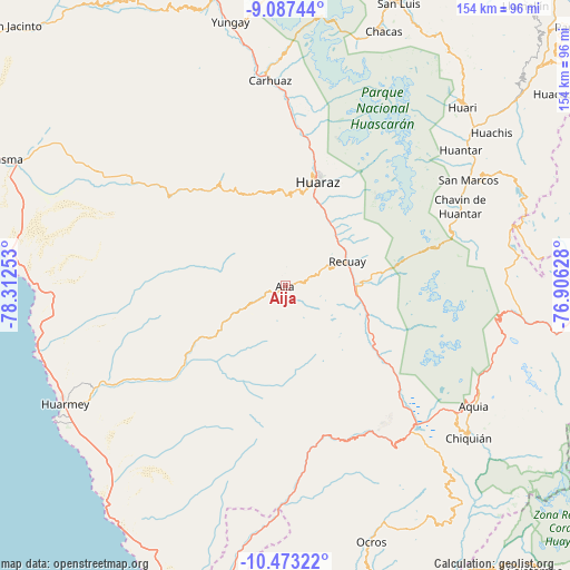
Aija GPS coordinates[2]
9° 46' 51.78" South, 77° 36' 33.84" West
| Map corner | latitude | longitude |
|---|---|---|
| Upper-left | -9.08744°, | -78.31253° |
| Center: | -9.78105°, | -77.6094° |
| Lower-right: | -10.47322°, | -76.90628° |
| Map W x H: | 154.1×154.1 km | = 95.8×95.8mi |
| max Lat: | -0.96667° ⇑37.2% North |
| Aija: | -9.78105° |
| min Lat: | ⇓62.8% South -18.01465° |
| min Long | Aija | max Long |
| -81.30472° | -77.6094° | -69.04167° |
| W 25.5%⇐ | ⇒74.5% E |
Elevation
Elevation of Aija is 3409 m = 11184 ft, and this is 1090.3 m = 3577 ft above average elevation for this country.
| Max E: |
5022 m = 16476 ft | 26.1% |
| Aija | 3409 m 11184 ft | |
| Avg. | 2318.7 m = 7607 ft | |
Min E: |
1 m = 3 ft | 73.9% |
See also: Peru elevation on elevation.city.
Geographical zone
Aija is located in South Torrid zone (between Equator and Tropic of Capricorn). Distance of Equator is 1087.6 km =675.8 mi to North.| Distance of | km | miles | from Aija |
|---|---|---|---|
| Equator | 1087.6 | 675.8 | to North |
| Tropic Capricorn | 1518.4 | 943.5 | to South |
| Antarctic Circle | 6313.6 | 3923.1 | to South |
| South Pole | 8919.5 | 5542.3 | to South |


Nearby cities:
15 places around Aija: (largest is in red/bold)
• Cajamarquilla
22.5 km =14 mi,  316°
316°
• Catac
19.4 km =12.1 mi,  96°
96°
• Coris
16.5 km =10.3 mi,  249°
249°
• Cotaparaco
24.4 km =15.2 mi,  177°
177°
• Huanchay
25.1 km =15.6 mi,  282°
282°
• Huaraz
29.5 km =18.3 mi,  17°
17°
• La Merced
5.2 km =3.2 mi,  350°
350°
• Malvas
17.1 km =10.6 mi,  208°
208°
• Olleros
21.5 km =13.4 mi,  40°
40°
• Pampas
27.6 km =17.1 mi,  297°
297°
• Pira
26.6 km =16.5 mi,  333°
333°
• Recuay
18 km =11.2 mi,  68°
68°
• Succha
7.3 km =4.5 mi,  217°
217°
• Tapacocha
26.4 km =16.4 mi,  173°
173°
• Ticapampa
17.8 km =11.1 mi,  78°
78°
Sources, notices
• [Note1] Compared only with cities in Peru existing in our database
• [Src1] Map data: © OpenStreetMap contributors (CC-BY-SA)
• [Src2] Other city data from geonames.org with taken over terms of usage.
• [Src3] Geographical zone / Annual Mean Temperature by Robert A. Rohde @ Wikipedia
