Namballe geodata
Namballe (Cajamarca) is a seat of a third-order administrative division; located in Peru in America/Lima (GMT-5) time zone. In our database, there are 305 cities with bigger population. Compared to other cities in Peru, 95.5% of cities are located further ↓South; 90.8% of cities are located further →East and 75.5% of cities have higher elevation than Namballe. Note1


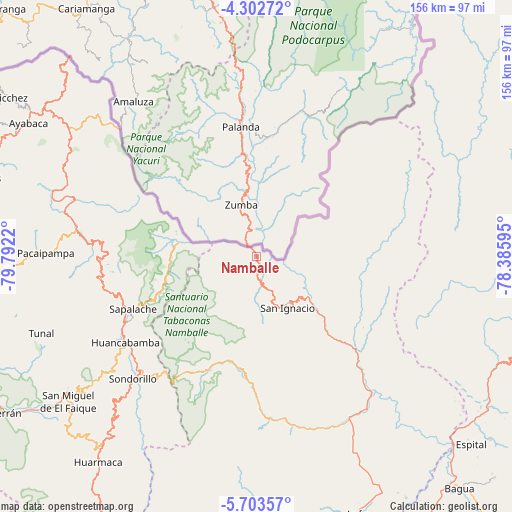
Namballe GPS coordinates[2]
5° 0' 12.672" South, 79° 5' 20.652" West
| Map corner | latitude | longitude |
|---|---|---|
| Upper-left | -4.30272°, | -79.7922° |
| Center: | -5.00352°, | -79.08907° |
| Lower-right: | -5.70357°, | -78.38595° |
| Map W x H: | 155.8×155.8 km | = 96.8×96.8mi |
| max Lat: | -0.96667° ⇑4.5% North |
| Namballe: | -5.00352° |
| min Lat: | ⇓95.5% South -18.01465° |
| min Long | Namballe | max Long |
| -81.30472° | -79.08907° | -69.04167° |
| W 9.2%⇐ | ⇒90.8% E |
Elevation
Elevation of Namballe is 681 m = 2234 ft, and this is 1637.7 m = 5373 ft below average elevation for this country.
| Max E: |
5022 m = 16476 ft | 75.5% |
| Avg. | 2318.7 m = 7607 ft | |
| Namballe | 681 m = 2234 ft | |
Min E: |
1 m = 3 ft | 24.5% |
See also: Peru elevation on elevation.city.
Geographical zone
Namballe is located in South Torrid zone (between Equator and Tropic of Capricorn). Distance of Equator is 556.3 km =345.7 mi to North.| Distance of | km | miles | from Namballe |
|---|---|---|---|
| Equator | 556.3 | 345.7 | to North |
| Tropic Capricorn | 2049.6 | 1273.6 | to South |
| Antarctic Circle | 6844.8 | 4253.2 | to South |
| South Pole | 9450.7 | 5872.4 | to South |


Nearby cities:
15 places around Namballe: (largest is in red/bold)
• Canchaque
69.9 km =43.4 mi,  234°
234°
• Chirinos
39.6 km =24.6 mi,  147°
147°
• Huabal
70.5 km =43.8 mi,  164°
164°
• Huancabamba
47.8 km =29.7 mi,  236°
236°
• La Coipa
53.9 km =33.5 mi, 152°
• Las Pirias
74.1 km =46 mi, 159°
• Pacaipampa
64.1 km =39.8 mi,  270°
270°
• Sallique
76.6 km =47.6 mi,  198°
198°
• San Ignacio
18.6 km =11.6 mi, 148°
• Sapalache
41.7 km =25.9 mi,  246°
246°
• Sondor
49.1 km =30.5 mi, 225°
• Sondorillo
53.1 km =33 mi, 225°
• Tabaconas
40.7 km =25.3 mi,  211°
211°
• Tunal
68.8 km =42.8 mi, 250°
• Yamango
75.7 km =47 mi,  255°
255°
Sources, notices
• [Note1] Compared only with cities in Peru existing in our database
• [Src1] Map data: © OpenStreetMap contributors (CC-BY-SA)
• [Src2] Other city data from geonames.org with taken over terms of usage.
• [Src3] Geographical zone / Annual Mean Temperature by Robert A. Rohde @ Wikipedia
