Sapalache geodata
Sapalache (Piura) is a seat of a third-order administrative division; located in Peru in America/Lima (GMT-5) time zone. In our database, there are 305 cities with bigger population. Compared to other cities in Peru, 94.8% of cities are located further ↓South; 93% of cities are located further →East and 61.2% of cities have higher elevation than Sapalache. Note1
Administrative division(s):
- Level 1: Piura
- Level 2: Provincia de Huancabamba
- Level 3: El Carmen De La Frontera


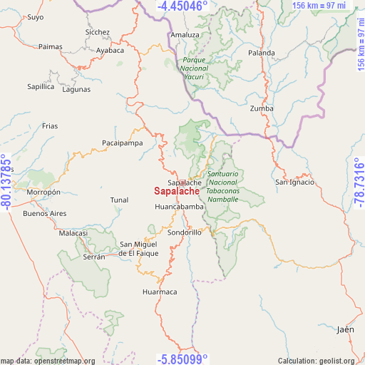
Sapalache GPS coordinates[2]
5° 9' 3.996" South, 79° 26' 4.992" West
| Map corner | latitude | longitude |
|---|---|---|
| Upper-left | -4.45046°, | -80.13785° |
| Center: | -5.15111°, | -79.43472° |
| Lower-right: | -5.85099°, | -78.7316° |
| Map W x H: | 155.7×155.7 km | = 96.7×96.7mi |
| max Lat: | -0.96667° ⇑5.2% North |
| Sapalache: | -5.15111° |
| min Lat: | ⇓94.8% South -18.01465° |
| min Long | Sapalache | max Long |
| -81.30472° | -79.43472° | -69.04167° |
| W 7%⇐ | ⇒93% E |
Elevation
Elevation of Sapalache is 2364 m = 7756 ft, and this is 45.3 m = 149 ft above average elevation for this country.
| Max E: |
5022 m = 16476 ft | 61.2% |
| Sapalache | 2364 m 7756 ft | |
| Avg. | 2318.7 m = 7607 ft | |
Min E: |
1 m = 3 ft | 38.8% |
See also: Peru elevation on elevation.city.
Geographical zone
Sapalache is located in South Torrid zone (between Equator and Tropic of Capricorn). Distance of Equator is 572.7 km =355.9 mi to North.| Distance of | km | miles | from Sapalache |
|---|---|---|---|
| Equator | 572.7 | 355.9 | to North |
| Tropic Capricorn | 2033.2 | 1263.4 | to South |
| Antarctic Circle | 6828.4 | 4243 | to South |
| South Pole | 9434.3 | 5862.2 | to South |


Nearby cities:
15 places around Sapalache: (largest is in red/bold)
• Canchaque
30.7 km =19.1 mi,  216°
216°
• Chalaco
41.7 km =25.9 mi,  287°
287°
• Huancabamba
9.9 km =6.2 mi,  190°
190°
• Huarmaca
47.1 km =29.3 mi, 191°
• Namballe
41.7 km =25.9 mi,  66°
66°
• Pacaipampa
31.1 km =19.3 mi,  303°
303°
• Paltashaco
50 km =31.1 mi,  276°
276°
• Sallique
57.6 km =35.8 mi,  166°
166°
• San Ignacio
48 km =29.8 mi,  89°
89°
• Santo Domingo
50.6 km =31.4 mi, 285°
• Sondor
18.2 km =11.3 mi, 170°
• Sondorillo
20.9 km =13 mi,  178°
178°
• Tabaconas
24.8 km =15.4 mi,  137°
137°
• Tunal
27.4 km =17 mi,  256°
256°
• Yamango
35 km =21.7 mi,  265°
265°
Sources, notices
• [Note1] Compared only with cities in Peru existing in our database
• [Src1] Map data: © OpenStreetMap contributors (CC-BY-SA)
• [Src2] Other city data from geonames.org with taken over terms of usage.
• [Src3] Geographical zone / Annual Mean Temperature by Robert A. Rohde @ Wikipedia
