Sondor geodata
Sondor (Piura) is a seat of a third-order administrative division; located in Peru in America/Lima (GMT-5) time zone. In our database, there are 305 cities with bigger population. Compared to other cities in Peru, 93.8% of cities are located further ↓South; 92.8% of cities are located further →East and 64.9% of cities have higher elevation than Sondor. Note1


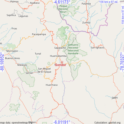
Sondor GPS coordinates[2]
5° 18' 43.992" South, 79° 24' 23.004" West
| Map corner | latitude | longitude |
|---|---|---|
| Upper-left | -4.61173°, | -80.10952° |
| Center: | -5.31222°, | -79.40639° |
| Lower-right: | -6.01191°, | -78.70327° |
| Map W x H: | 155.7×155.7 km | = 96.7×96.7mi |
| max Lat: | -0.96667° ⇑6.2% North |
| Sondor: | -5.31222° |
| min Lat: | ⇓93.8% South -18.01465° |
| min Long | Sondor | max Long |
| -81.30472° | -79.40639° | -69.04167° |
| W 7.2%⇐ | ⇒92.8% E |
Elevation
Elevation of Sondor is 2045 m = 6709 ft, and this is 273.7 m = 898 ft below average elevation for this country.
| Max E: |
5022 m = 16476 ft | 64.9% |
| Avg. | 2318.7 m = 7607 ft | |
| Sondor | 2045 m = 6709 ft | |
Min E: |
1 m = 3 ft | 35.1% |
See also: Peru elevation on elevation.city.
Geographical zone
Sondor is located in South Torrid zone (between Equator and Tropic of Capricorn). Distance of Equator is 590.7 km =367 mi to North.| Distance of | km | miles | from Sondor |
|---|---|---|---|
| Equator | 590.7 | 367 | to North |
| Tropic Capricorn | 2015.3 | 1252.2 | to South |
| Antarctic Circle | 6810.5 | 4231.8 | to South |
| South Pole | 9416.4 | 5851.1 | to South |


Nearby cities:
15 places around Sondor: (largest is in red/bold)
• Canchaque
22.5 km =14 mi,  252°
252°
• Chalaco
52.6 km =32.7 mi,  305°
305°
• Chirinos
56.3 km =35 mi,  89°
89°
• Huancabamba
9.5 km =5.9 mi,  329°
329°
• Huarmaca
31 km =19.3 mi,  204°
204°
• Namballe
49.1 km =30.5 mi,  45°
45°
• Pacaipampa
45.6 km =28.3 mi,  320°
320°
• Sallique
39.5 km =24.5 mi,  164°
164°
• San Felipe
51.7 km =32.1 mi,  168°
168°
• San Ignacio
48.5 km =30.1 mi,  67°
67°
• Sapalache
18.2 km =11.3 mi,  350°
350°
• Sondorillo
4 km =2.5 mi,  221°
221°
• Tabaconas
13.7 km =8.5 mi, 91°
• Tunal
31.9 km =19.8 mi,  291°
291°
• Yamango
40.9 km =25.4 mi, 291°
Sources, notices
• [Note1] Compared only with cities in Peru existing in our database
• [Src1] Map data: © OpenStreetMap contributors (CC-BY-SA)
• [Src2] Other city data from geonames.org with taken over terms of usage.
• [Src3] Geographical zone / Annual Mean Temperature by Robert A. Rohde @ Wikipedia
