Sondorillo geodata
Sondorillo (Piura) is a seat of a third-order administrative division; located in Peru in America/Lima (GMT-5) time zone. In our database, there are 305 cities with bigger population. Compared to other cities in Peru, 93.6% of cities are located further ↓South; 93% of cities are located further →East and 67.1% of cities have higher elevation than Sondorillo. Note1


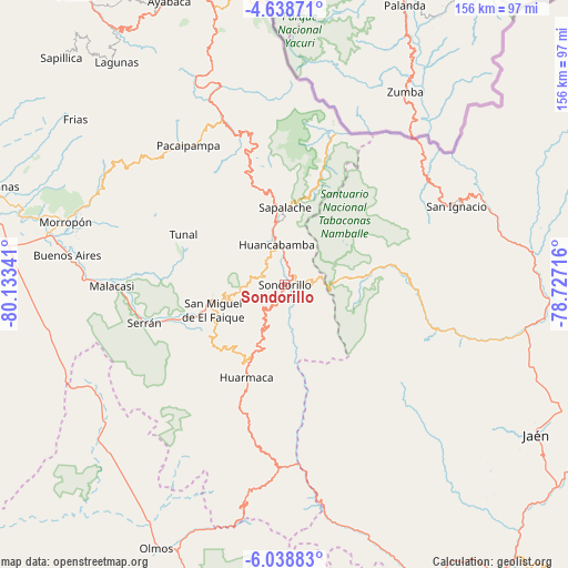
Sondorillo GPS coordinates[2]
5° 20' 21.012" South, 79° 25' 49.008" West
| Map corner | latitude | longitude |
|---|---|---|
| Upper-left | -4.63871°, | -80.13341° |
| Center: | -5.33917°, | -79.43028° |
| Lower-right: | -6.03883°, | -78.72716° |
| Map W x H: | 155.7×155.7 km | = 96.7×96.7mi |
| max Lat: | -0.96667° ⇑6.4% North |
| Sondorillo: | -5.33917° |
| min Lat: | ⇓93.6% South -18.01465° |
| min Long | Sondorillo | max Long |
| -81.30472° | -79.43028° | -69.04167° |
| W 7%⇐ | ⇒93% E |
Elevation
Elevation of Sondorillo is 1884 m = 6181 ft, and this is 434.7 m = 1426 ft below average elevation for this country.
| Max E: |
5022 m = 16476 ft | 67.1% |
| Avg. | 2318.7 m = 7607 ft | |
| Sondorillo | 1884 m = 6181 ft | |
Min E: |
1 m = 3 ft | 32.9% |
See also: Peru elevation on elevation.city.
Geographical zone
Sondorillo is located in South Torrid zone (between Equator and Tropic of Capricorn). Distance of Equator is 593.7 km =368.9 mi to North.| Distance of | km | miles | from Sondorillo |
|---|---|---|---|
| Equator | 593.7 | 368.9 | to North |
| Tropic Capricorn | 2012.3 | 1250.4 | to South |
| Antarctic Circle | 6807.5 | 4230 | to South |
| South Pole | 9413.4 | 5849.2 | to South |


Nearby cities:
15 places around Sondorillo: (largest is in red/bold)
• Canchaque
19.2 km =11.9 mi,  258°
258°
• Chalaco
52.3 km =32.5 mi,  309°
309°
• Huancabamba
11.4 km =7.1 mi,  348°
348°
• Huarmaca
27.2 km =16.9 mi,  201°
201°
• Namballe
53.1 km =33 mi,  45°
45°
• Pacaipampa
46.4 km =28.8 mi,  325°
325°
• Paltashaco
56.8 km =35.3 mi,  297°
297°
• Sallique
37.4 km =23.2 mi,  159°
159°
• San Felipe
49.4 km =30.7 mi, 164°
• San Ignacio
52.1 km =32.4 mi,  65°
65°
• Sapalache
20.9 km =13 mi,  358°
358°
• Sondor
4 km =2.5 mi,  41°
41°
• Tabaconas
16.6 km =10.3 mi,  80°
80°
• Tunal
30.7 km =19.1 mi, 298°
• Yamango
39.7 km =24.7 mi, 296°
Sources, notices
• [Note1] Compared only with cities in Peru existing in our database
• [Src1] Map data: © OpenStreetMap contributors (CC-BY-SA)
• [Src2] Other city data from geonames.org with taken over terms of usage.
• [Src3] Geographical zone / Annual Mean Temperature by Robert A. Rohde @ Wikipedia
