San Ignacio geodata
San Ignacio (Cajamarca) is a seat of a third-order administrative division; located in Peru in America/Lima (GMT-5) time zone. With population of 7,912 people, there are 171 cities with bigger population in this country. Compared to other cities in Peru, 94.9% of cities are located further ↓South; 89.9% of cities are located further →East and 70.8% of cities have higher elevation than San Ignacio. Note1
Administrative division(s):
- Level 1: Cajamarca
- Level 2: Provincia de San Ignacio
- Level 3: San Ignacio


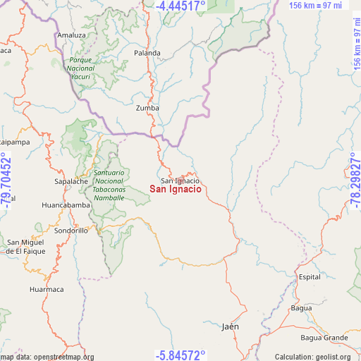
San Ignacio GPS coordinates[2]
5° 8' 44.988" South, 79° 0' 5.004" West
| Map corner | latitude | longitude |
|---|---|---|
| Upper-left | -4.44517°, | -79.70452° |
| Center: | -5.14583°, | -79.00139° |
| Lower-right: | -5.84572°, | -78.29827° |
| Map W x H: | 155.7×155.7 km | = 96.7×96.7mi |
| max Lat: | -0.96667° ⇑5.1% North |
| San Ignacio: | -5.14583° |
| min Lat: | ⇓94.9% South -18.01465° |
| min Long | San Ignacio | max Long |
| -81.30472° | -79.00139° | -69.04167° |
| W 10.1%⇐ | ⇒89.9% E |
Elevation
Elevation of San Ignacio is 1271 m = 4170 ft, and this is 1047.7 m = 3437 ft below average elevation for this country.
| Max E: |
5022 m = 16476 ft | 70.8% |
| Avg. | 2318.7 m = 7607 ft | |
| San Ignacio | 1271 m = 4170 ft | |
Min E: |
1 m = 3 ft | 29.2% |
See also: Peru elevation on elevation.city.
Geographical zone
San Ignacio is located in South Torrid zone (between Equator and Tropic of Capricorn). Distance of Equator is 572.2 km =355.5 mi to North.| Distance of | km | miles | from San Ignacio |
|---|---|---|---|
| Equator | 572.2 | 355.5 | to North |
| Tropic Capricorn | 2033.8 | 1263.7 | to South |
| Antarctic Circle | 6829 | 4243.3 | to South |
| South Pole | 9434.9 | 5862.6 | to South |


Nearby cities:
15 places around San Ignacio: (largest is in red/bold)
• Aramango
69.5 km =43.2 mi,  115°
115°
• Bellavista
67.9 km =42.2 mi,  148°
148°
• Canchaque
71 km =44.1 mi,  249°
249°
• Chirinos
21.1 km =13.1 mi, 147°
• Huabal
53 km =32.9 mi,  170°
170°
• Huancabamba
50.8 km =31.6 mi,  258°
258°
• Jaén
66 km =41 mi,  161°
161°
• La Coipa
35.4 km =22 mi, 154°
• Las Pirias
56 km =34.8 mi, 162°
• Namballe
18.6 km =11.6 mi,  328°
328°
• Sallique
66.3 km =41.2 mi,  211°
211°
• Sapalache
48 km =29.8 mi,  269°
269°
• Sondor
48.5 km =30.1 mi, 247°
• Sondorillo
52.1 km =32.4 mi, 245°
• Tabaconas
36.4 km =22.6 mi,  238°
238°
Sources, notices
• [Note1] Compared only with cities in Peru existing in our database
• [Src1] Map data: © OpenStreetMap contributors (CC-BY-SA)
• [Src2] Other city data from geonames.org with taken over terms of usage.
• [Src3] Geographical zone / Annual Mean Temperature by Robert A. Rohde @ Wikipedia
