Bagua Grande geodata
Bagua Grande (Amazonas) is a seat of a third-order administrative division; located in Peru in America/Lima (GMT-5) time zone. With population of 20,382 people, there are 85 cities with bigger population in this country. Compared to other cities in Peru, 91.6% of cities are located further ↓South; 85.1% of cities are located further →East and 78.5% of cities have higher elevation than Bagua Grande. Note1


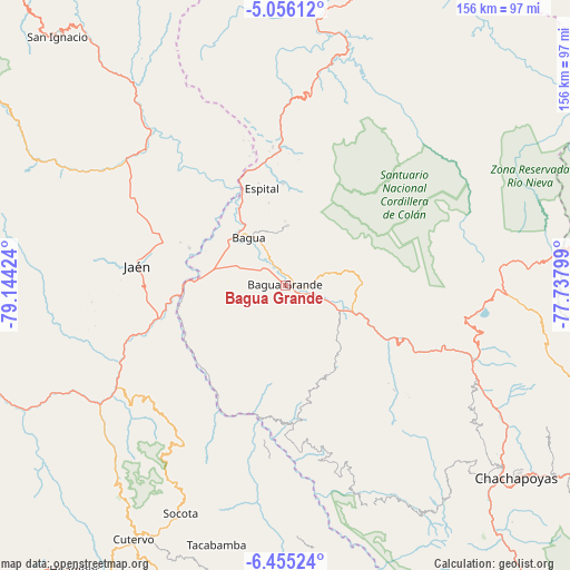
Bagua Grande GPS coordinates[2]
5° 45' 21.996" South, 78° 26' 27.996" West
| Map corner | latitude | longitude |
|---|---|---|
| Upper-left | -5.05612°, | -79.14424° |
| Center: | -5.75611°, | -78.44111° |
| Lower-right: | -6.45524°, | -77.73799° |
| Map W x H: | 155.6×155.6 km | = 96.7×96.7mi |
| max Lat: | -0.96667° ⇑8.4% North |
| Bagua Grande: | -5.75611° |
| min Lat: | ⇓91.6% South -18.01465° |
| min Long | Bagua Grande | max Long |
| -81.30472° | -78.44111° | -69.04167° |
| W 14.9%⇐ | ⇒85.1% E |
Elevation
Elevation of Bagua Grande is 450 m = 1476 ft, and this is 1868.7 m = 6131 ft below average elevation for this country.
| Max E: |
5022 m = 16476 ft | 78.5% |
| Avg. | 2318.7 m = 7607 ft | |
| Bagua Grande | 450 m = 1476 ft | |
Min E: |
1 m = 3 ft | 21.5% |
See also: Peru elevation on elevation.city.
Geographical zone
Bagua Grande is located in South Torrid zone (between Equator and Tropic of Capricorn). Distance of Equator is 640 km =397.7 mi to North.| Distance of | km | miles | from Bagua Grande |
|---|---|---|---|
| Equator | 640 | 397.7 | to North |
| Tropic Capricorn | 1965.9 | 1221.6 | to South |
| Antarctic Circle | 6761.2 | 4201.2 | to South |
| South Pole | 9367 | 5820.4 | to South |


Nearby cities:
15 places around Bagua Grande: (largest is in red/bold)
• Aramango
37.8 km =23.5 mi,  0°
0°
• Bagua
17.1 km =10.6 mi,  322°
322°
• Bellavista
28.1 km =17.5 mi,  291°
291°
• Cajaruro
2.8 km =1.7 mi,  38°
38°
• Choros
32.3 km =20.1 mi,  240°
240°
• Cujillo
41.4 km =25.7 mi,  194°
194°
• Cumba
31.4 km =19.5 mi,  231°
231°
• El Parco District
15.1 km =9.4 mi,  345°
345°
• Huabal
55.6 km =34.5 mi, 286°
• Jamalca
23.4 km =14.5 mi,  121°
121°
• Jaén
40.9 km =25.4 mi,  277°
277°
• La Peca
16.1 km =10 mi, 2°
• La Sacilia
38.4 km =23.9 mi, 235°
• Las Pirias
47.7 km =29.6 mi, 287°
• Lonya Grande
37.7 km =23.4 mi,  176°
176°
Sources, notices
• [Note1] Compared only with cities in Peru existing in our database
• [Src1] Map data: © OpenStreetMap contributors (CC-BY-SA)
• [Src2] Other city data from geonames.org with taken over terms of usage.
• [Src3] Geographical zone / Annual Mean Temperature by Robert A. Rohde @ Wikipedia
