Llama geodata
Llama (Cajamarca) is a seat of a third-order administrative division; located in Peru in America/Lima (GMT-5) time zone. In our database, there are 305 cities with bigger population. Compared to other cities in Peru, 84.4% of cities are located further ↓South; 91.1% of cities are located further →East and 64.6% of cities have higher elevation than Llama. Note1


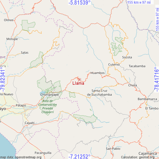
Llama GPS coordinates[2]
6° 30' 51.984" South, 79° 7' 13.008" West
| Map corner | latitude | longitude |
|---|---|---|
| Upper-left | -5.81539°, | -79.82341° |
| Center: | -6.51444°, | -79.12028° |
| Lower-right: | -7.21252°, | -78.41716° |
| Map W x H: | 155.3×155.4 km | = 96.5×96.6mi |
| max Lat: | -0.96667° ⇑15.6% North |
| Llama: | -6.51444° |
| min Lat: | ⇓84.4% South -18.01465° |
| min Long | Llama | max Long |
| -81.30472° | -79.12028° | -69.04167° |
| W 8.9%⇐ | ⇒91.1% E |
Elevation
Elevation of Llama is 2096 m = 6877 ft, and this is 222.7 m = 731 ft below average elevation for this country.
| Max E: |
5022 m = 16476 ft | 64.6% |
| Avg. | 2318.7 m = 7607 ft | |
| Llama | 2096 m = 6877 ft | |
Min E: |
1 m = 3 ft | 35.4% |
See also: Peru elevation on elevation.city.
Geographical zone
Llama is located in South Torrid zone (between Equator and Tropic of Capricorn). Distance of Equator is 724.3 km =450.1 mi to North.| Distance of | km | miles | from Llama |
|---|---|---|---|
| Equator | 724.3 | 450.1 | to North |
| Tropic Capricorn | 1881.6 | 1169.2 | to South |
| Antarctic Circle | 6676.8 | 4148.8 | to South |
| South Pole | 9282.7 | 5768 | to South |


Nearby cities:
15 places around Llama: (largest is in red/bold)
• Catache
20.3 km =12.6 mi,  151°
151°
• Chongoyape
32.8 km =20.4 mi,  244°
244°
• Cochabamba
24.6 km =15.3 mi,  81°
81°
• Cutervo
34.1 km =21.2 mi,  61°
61°
• Huambos
17.8 km =11.1 mi,  72°
72°
• Incahuasi
37.9 km =23.5 mi,  324°
324°
• La Florida
39.5 km =24.5 mi,  180°
180°
• Licupis
16.7 km =10.4 mi,  306°
306°
• Miracosta
21.9 km =13.6 mi,  304°
304°
• Oyotún
41.8 km =26 mi,  208°
208°
• Querocotillo
28.2 km =17.5 mi,  18°
18°
• Querocoto
19.7 km =12.2 mi,  28°
28°
• Sexi
9.4 km =5.8 mi,  125°
125°
• Tocmoche
29 km =18 mi,  293°
293°
• Uticyacu
37.8 km =23.5 mi,  110°
110°
Sources, notices
• [Note1] Compared only with cities in Peru existing in our database
• [Src1] Map data: © OpenStreetMap contributors (CC-BY-SA)
• [Src2] Other city data from geonames.org with taken over terms of usage.
• [Src3] Geographical zone / Annual Mean Temperature by Robert A. Rohde @ Wikipedia
