Chongoyape geodata
Chongoyape (Lambayeque) is a seat of a third-order administrative division; located in Peru in America/Lima (GMT-5) time zone. With population of 16,061 people, there are 98 cities with bigger population in this country. Compared to other cities in Peru, 83% of cities are located further ↓South; 92.7% of cities are located further →East and 83.7% of cities have higher elevation than Chongoyape. Note1


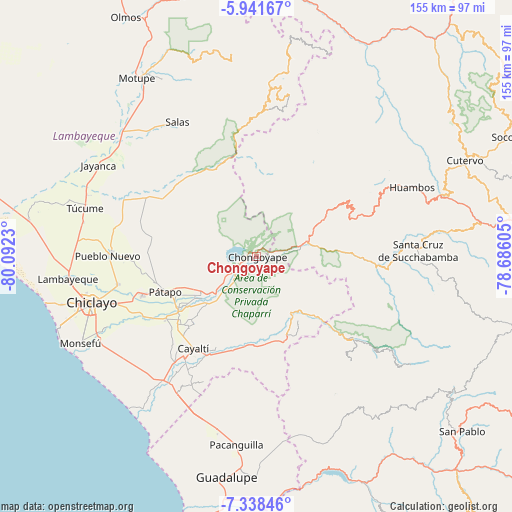
Chongoyape GPS coordinates[2]
6° 38' 26.016" South, 79° 23' 21.012" West
| Map corner | latitude | longitude |
|---|---|---|
| Upper-left | -5.94167°, | -80.0923° |
| Center: | -6.64056°, | -79.38917° |
| Lower-right: | -7.33846°, | -78.68605° |
| Map W x H: | 155.3×155.3 km | = 96.5×96.5mi |
| max Lat: | -0.96667° ⇑17% North |
| Chongoyape: | -6.64056° |
| min Lat: | ⇓83% South -18.01465° |
| min Long | Chongoyape | max Long |
| -81.30472° | -79.38917° | -69.04167° |
| W 7.3%⇐ | ⇒92.7% E |
Elevation
Elevation of Chongoyape is 214 m = 702 ft, and this is 2104.7 m = 6905 ft below average elevation for this country.
| Max E: |
5022 m = 16476 ft | 83.7% |
| Avg. | 2318.7 m = 7607 ft | |
| Chongoyape | 214 m = 702 ft | |
Min E: |
1 m = 3 ft | 16.3% |
See also: Peru elevation on elevation.city.
Geographical zone
Chongoyape is located in South Torrid zone (between Equator and Tropic of Capricorn). Distance of Equator is 738.4 km =458.8 mi to North.| Distance of | km | miles | from Chongoyape |
|---|---|---|---|
| Equator | 738.4 | 458.8 | to North |
| Tropic Capricorn | 1867.6 | 1160.5 | to South |
| Antarctic Circle | 6662.8 | 4140.1 | to South |
| South Pole | 9268.7 | 5759.3 | to South |


Nearby cities:
15 places around Chongoyape: (largest is in red/bold)
• Catache
39.5 km =24.5 mi,  95°
95°
• Ferreñafe
44.1 km =27.4 mi,  270°
270°
• La Florida
39.1 km =24.3 mi,  130°
130°
• Licupis
29 km =18 mi,  34°
34°
• Llama
32.8 km =20.4 mi,  64°
64°
• Manuel Antonio Mesones Muro
38.5 km =23.9 mi, 269°
• Miracosta
28.7 km =17.8 mi,  23°
23°
• Nanchoc
39 km =24.2 mi,  155°
155°
• Niepos
42.9 km =26.7 mi,  137°
137°
• Nueva Arica
26.3 km =16.3 mi,  168°
168°
• Oyotún
24.7 km =15.3 mi, 156°
• Picsi
42.9 km =26.7 mi,  258°
258°
• Saña
37.6 km =23.4 mi,  214°
214°
• Sexi
38.3 km =23.8 mi,  77°
77°
• Tocmoche
25.5 km =15.8 mi,  6°
6°
Sources, notices
• [Note1] Compared only with cities in Peru existing in our database
• [Src1] Map data: © OpenStreetMap contributors (CC-BY-SA)
• [Src2] Other city data from geonames.org with taken over terms of usage.
• [Src3] Geographical zone / Annual Mean Temperature by Robert A. Rohde @ Wikipedia
