La Florida geodata
La Florida (Cajamarca) is a seat of a third-order administrative division; located in Peru in America/Lima (GMT-5) time zone. In our database, there are 305 cities with bigger population. Compared to other cities in Peru, 81% of cities are located further ↓South; 91.2% of cities are located further →East and 72.4% of cities have higher elevation than La Florida. Note1


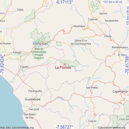
La Florida GPS coordinates[2]
6° 52' 10.992" South, 79° 7' 15.996" West
| Map corner | latitude | longitude |
|---|---|---|
| Upper-left | -6.17115°, | -79.82424° |
| Center: | -6.86972°, | -79.12111° |
| Lower-right: | -7.56727°, | -78.41799° |
| Map W x H: | 155.2×155.2 km | = 96.4×96.4mi |
| max Lat: | -0.96667° ⇑19% North |
| La Florida: | -6.86972° |
| min Lat: | ⇓81% South -18.01465° |
| min Long | La Florida | max Long |
| -81.30472° | -79.12111° | -69.04167° |
| W 8.8%⇐ | ⇒91.2% E |
Elevation
Elevation of La Florida is 1041 m = 3415 ft, and this is 1277.7 m = 4192 ft below average elevation for this country.
| Max E: |
5022 m = 16476 ft | 72.4% |
| Avg. | 2318.7 m = 7607 ft | |
| La Florida | 1041 m = 3415 ft | |
Min E: |
1 m = 3 ft | 27.6% |
See also: Peru elevation on elevation.city.
Geographical zone
La Florida is located in South Torrid zone (between Equator and Tropic of Capricorn). Distance of Equator is 763.8 km =474.6 mi to North.| Distance of | km | miles | from La Florida |
|---|---|---|---|
| Equator | 763.8 | 474.6 | to North |
| Tropic Capricorn | 1842.1 | 1144.6 | to South |
| Antarctic Circle | 6637.3 | 4124.2 | to South |
| South Pole | 9243.2 | 5743.5 | to South |


Nearby cities:
15 places around La Florida: (largest is in red/bold)
• Catache
23.7 km =14.7 mi,  24°
24°
• Chongoyape
39.1 km =24.3 mi,  310°
310°
• Chugur
46.8 km =29.1 mi,  61°
61°
• El Prado
22.6 km =14 mi,  143°
143°
• Llama
39.5 km =24.5 mi,  0°
0°
• Llapa
35.9 km =22.3 mi,  110°
110°
• Nanchoc
16.7 km =10.4 mi,  233°
233°
• Niepos
6.4 km =4 mi,  187°
187°
• Nueva Arica
24.5 km =15.2 mi,  269°
269°
• Oyotún
20.1 km =12.5 mi,  278°
278°
• San Gregorio
20.2 km =12.6 mi,  173°
173°
• San Pablo
42 km =26.1 mi,  130°
130°
• Sexi
34.9 km =21.7 mi,  12°
12°
• Tembladera
44.3 km =27.5 mi,  184°
184°
• Uticyacu
44.1 km =27.4 mi,  53°
53°
Sources, notices
• [Note1] Compared only with cities in Peru existing in our database
• [Src1] Map data: © OpenStreetMap contributors (CC-BY-SA)
• [Src2] Other city data from geonames.org with taken over terms of usage.
• [Src3] Geographical zone / Annual Mean Temperature by Robert A. Rohde @ Wikipedia
