Oyotún geodata
Oyotún (Lambayeque) is a populated place; located in Peru in America/Lima (GMT-5) time zone. With population of 6,330 people, there are 200 cities with bigger population in this country. Compared to other cities in Peru, 81.3% of cities are located further ↓South; 92.2% of cities are located further →East and 84.1% of cities have higher elevation than Oyotún. Note1


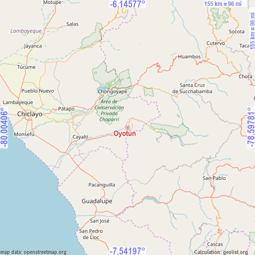
Oyotún GPS coordinates[2]
6° 50' 39.768" South, 79° 18' 3.348" West
| Map corner | latitude | longitude |
|---|---|---|
| Upper-left | -6.14577°, | -80.00406° |
| Center: | -6.84438°, | -79.30093° |
| Lower-right: | -7.54197°, | -78.59781° |
| Map W x H: | 155.2×155.2 km | = 96.4×96.4mi |
| max Lat: | -0.96667° ⇑18.7% North |
| Oyotún: | -6.84438° |
| min Lat: | ⇓81.3% South -18.01465° |
| min Long | Oyotún | max Long |
| -81.30472° | -79.30093° | -69.04167° |
| W 7.8%⇐ | ⇒92.2% E |
Elevation
Elevation of Oyotún is 207 m = 679 ft, and this is 2111.7 m = 6928 ft below average elevation for this country.
| Max E: |
5022 m = 16476 ft | 84.1% |
| Avg. | 2318.7 m = 7607 ft | |
| Oyotún | 207 m = 679 ft | |
Min E: |
1 m = 3 ft | 15.9% |
See also: Peru elevation on elevation.city.
Geographical zone
Oyotún is located in South Torrid zone (between Equator and Tropic of Capricorn). Distance of Equator is 761 km =472.9 mi to North.| Distance of | km | miles | from Oyotún |
|---|---|---|---|
| Equator | 761 | 472.9 | to North |
| Tropic Capricorn | 1844.9 | 1146.4 | to South |
| Antarctic Circle | 6640.2 | 4126 | to South |
| South Pole | 9246 | 5745.2 | to South |


Nearby cities:
15 places around Oyotún: (largest is in red/bold)
• Catache
35 km =21.7 mi,  57°
57°
• Chepén
44.4 km =27.6 mi,  197°
197°
• Chongoyape
24.7 km =15.3 mi,  336°
336°
• El Prado
39.3 km =24.4 mi,  122°
122°
• La Florida
20.1 km =12.5 mi,  98°
98°
• Llama
41.8 km =26 mi,  28°
28°
• Mocupe
38.7 km =24 mi,  245°
245°
• Nanchoc
14.4 km =8.9 mi,  153°
153°
• Niepos
21.1 km =13.1 mi, 115°
• Nueva Arica
5.6 km =3.5 mi,  235°
235°
• Pacanga
42 km =26.1 mi,  211°
211°
• Pueblo Nuevo
44.9 km =27.9 mi, 211°
• San Gregorio
31.9 km =19.8 mi,  135°
135°
• Saña
32.1 km =19.9 mi,  255°
255°
• Sexi
41.6 km =25.8 mi,  41°
41°
Sources, notices
• [Note1] Compared only with cities in Peru existing in our database
• [Src1] Map data: © OpenStreetMap contributors (CC-BY-SA)
• [Src2] Other city data from geonames.org with taken over terms of usage.
• [Src3] Geographical zone / Annual Mean Temperature by Robert A. Rohde @ Wikipedia
