La Huaca geodata
La Huaca (Piura) is a seat of a third-order administrative division; located in Peru in America/Lima (GMT-5) time zone. With population of 8,468 people, there are 164 cities with bigger population in this country. Compared to other cities in Peru, 95.8% of cities are located further ↓South; 99.1% of cities are located further →East and 95.4% of cities have higher elevation than La Huaca. Note1


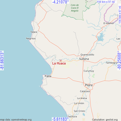
La Huaca GPS coordinates[2]
4° 54' 42.012" South, 80° 57' 36" West
| Map corner | latitude | longitude |
|---|---|---|
| Upper-left | -4.21078°, | -81.66313° |
| Center: | -4.91167°, | -80.96° |
| Lower-right: | -5.61183°, | -80.25688° |
| Map W x H: | 155.8×155.8 km | = 96.8×96.8mi |
| max Lat: | -0.96667° ⇑4.2% North |
| La Huaca: | -4.91167° |
| min Lat: | ⇓95.8% South -18.01465° |
| min Long | La Huaca | max Long |
| -81.30472° | -80.96° | -69.04167° |
| W 0.9%⇐ | ⇒99.1% E |
Elevation
Elevation of La Huaca is 26 m = 85 ft, and this is 2292.7 m = 7522 ft below average elevation for this country.
| Max E: |
5022 m = 16476 ft | 95.4% |
| Avg. | 2318.7 m = 7607 ft | |
| La Huaca | 26 m = 85 ft | |
Min E: |
1 m = 3 ft | 4.6% |
See also: Peru elevation on elevation.city.
Geographical zone
La Huaca is located in South Torrid zone (between Equator and Tropic of Capricorn). Distance of Equator is 546.1 km =339.3 mi to North.| Distance of | km | miles | from La Huaca |
|---|---|---|---|
| Equator | 546.1 | 339.3 | to North |
| Tropic Capricorn | 2059.8 | 1279.9 | to South |
| Antarctic Circle | 6855 | 4259.5 | to South |
| South Pole | 9460.9 | 5878.7 | to South |


Nearby cities:
15 places around La Huaca: (largest is in red/bold)
• Amotape
7 km =4.3 mi,  298°
298°
• Arenal
8.1 km =5 mi,  292°
292°
• Catacaos
50 km =31.1 mi,  142°
142°
• Marcavelica
28.5 km =17.7 mi,  82°
82°
• Negritos
47.8 km =29.7 mi,  306°
306°
• Paita
26.1 km =16.2 mi,  220°
220°
• Piura
48 km =29.8 mi,  130°
130°
• Querecotillo
35.8 km =22.2 mi, 76°
• Salinera Colán
18 km =11.2 mi, 221°
• Salitral
31.5 km =19.6 mi, 78°
• San Jacinto
12 km =7.5 mi,  50°
50°
• Sojo
16 km =9.9 mi,  85°
85°
• Sullana
30.4 km =18.9 mi, 88°
• Talara
50.8 km =31.6 mi,  317°
317°
• Tamarindo
4.1 km =2.5 mi,  339°
339°
Sources, notices
• [Note1] Compared only with cities in Peru existing in our database
• [Src1] Map data: © OpenStreetMap contributors (CC-BY-SA)
• [Src2] Other city data from geonames.org with taken over terms of usage.
• [Src3] Geographical zone / Annual Mean Temperature by Robert A. Rohde @ Wikipedia
