Amotape geodata
Amotape (Piura) is a seat of a third-order administrative division; located in Peru in America/Lima (GMT-5) time zone. In our database, there are 305 cities with bigger population. Compared to other cities in Peru, 96.2% of cities are located further ↓South; 99.3% of cities are located further →East and 97.8% of cities have higher elevation than Amotape. Note1


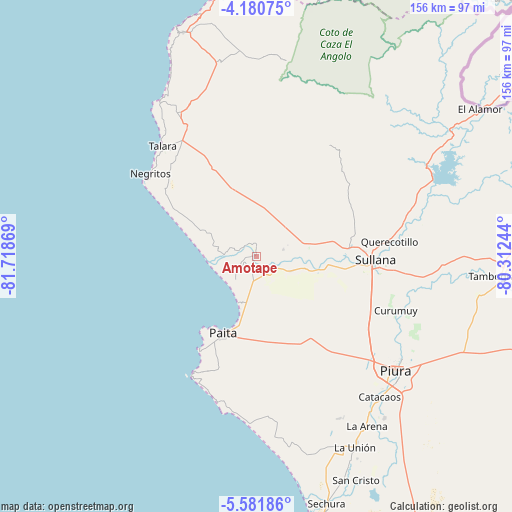
Amotape GPS coordinates[2]
4° 52' 54.012" South, 81° 0' 56.016" West
| Map corner | latitude | longitude |
|---|---|---|
| Upper-left | -4.18075°, | -81.71869° |
| Center: | -4.88167°, | -81.01556° |
| Lower-right: | -5.58186°, | -80.31244° |
| Map W x H: | 155.8×155.8 km | = 96.8×96.8mi |
| max Lat: | -0.96667° ⇑3.8% North |
| Amotape: | -4.88167° |
| min Lat: | ⇓96.2% South -18.01465° |
| min Long | Amotape | max Long |
| -81.30472° | -81.01556° | -69.04167° |
| W 0.7%⇐ | ⇒99.3% E |
Elevation
Elevation of Amotape is 14 m = 46 ft, and this is 2304.7 m = 7561 ft below average elevation for this country.
| Max E: |
5022 m = 16476 ft | 97.8% |
| Avg. | 2318.7 m = 7607 ft | |
| Amotape | 14 m = 46 ft | |
Min E: |
1 m = 3 ft | 2.2% |
See also: Peru elevation on elevation.city.
Geographical zone
Amotape is located in South Torrid zone (between Equator and Tropic of Capricorn). Distance of Equator is 542.8 km =337.3 mi to North.| Distance of | km | miles | from Amotape |
|---|---|---|---|
| Equator | 542.8 | 337.3 | to North |
| Tropic Capricorn | 2063.1 | 1282 | to South |
| Antarctic Circle | 6858.4 | 4261.6 | to South |
| South Pole | 9464.3 | 5880.8 | to South |


Nearby cities:
15 places around Amotape: (largest is in red/bold)
• Arenal
1.3 km =0.8 mi,  262°
262°
• La Huaca
7 km =4.3 mi,  118°
118°
• Lobitos
55.9 km =34.7 mi,  327°
327°
• Marcavelica
34.4 km =21.4 mi,  89°
89°
• Negritos
40.8 km =25.4 mi,  308°
308°
• Paita
25.5 km =15.8 mi,  205°
205°
• Piura
54.8 km =34.1 mi,  129°
129°
• Querecotillo
41.3 km =25.7 mi,  83°
83°
• Salinera Colán
17.8 km =11.1 mi,  198°
198°
• Salitral
37.2 km =23.1 mi, 85°
• San Jacinto
16 km =9.9 mi,  74°
74°
• Sojo
22.2 km =13.8 mi,  95°
95°
• Sullana
36.7 km =22.8 mi, 93°
• Talara
44.2 km =27.5 mi,  319°
319°
• Tamarindo
4.7 km =2.9 mi, 84°
Sources, notices
• [Note1] Compared only with cities in Peru existing in our database
• [Src1] Map data: © OpenStreetMap contributors (CC-BY-SA)
• [Src2] Other city data from geonames.org with taken over terms of usage.
• [Src3] Geographical zone / Annual Mean Temperature by Robert A. Rohde @ Wikipedia
